
Introducing Geozén: Transforming Business with Spatial Data Integration


Introduction to Geozén
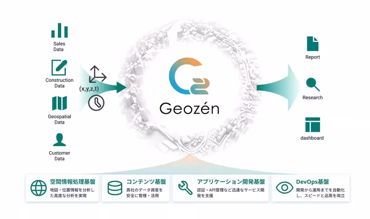
International Kōgyō Co., Ltd. has launched an innovative cloud-native spatial information platform called Geozén. Designed to facilitate the digital transformation (DX) of organizations, it integrates a diverse array of business data centered around spatial information.
Revolutionizing Business Data
The Geozén platform utilizes a state-of-the-art microservices architecture. This approach enhances productivity by 40%, compared to traditional development methods. It allows for rapid business deployments across multiple sectors, including infrastructure management, asset management, marketing, and disaster prevention, all using location-based data to promote unified decision-making and increased efficiency.
The Challenge of Data Silos
Organizations often face significant barriers in implementing DX due to fragmented data systems across departments. It is common to encounter disparate databases—such as equipment ledgers, customer relationship management (CRM) records, and IoT sensor data—that remain siloed and unconnected. However, all these data points share a crucial element: the location from which they derive.
International Kōgyō firmly believes that this spatial information serves as the essential axis for unifying these disparate datasets and creating a digital twin of the business environment.
Breaking Down Barriers with Geozén
Geozén aims to dismantle the barriers erected by traditionally specialized and insular Geographic Information Systems (GIS). By establishing spatial information as the operating system for businesses, Geozén looks ahead to a future with connections to urban operating systems and smart city infrastructure.
Creating a Data Integration Hub
Geozén embodies a shift from building monolithic systems to employing a microservices design, where necessary functionalities are connected like building blocks. This design enables Geozén to function as a hub, layering all data spatially and providing significant value in several key areas:
1. Overall Business Optimization: By integrating various departments' data—such as construction and inspection data from infrastructure units and customer data from sales—Geozén enables comprehensive visibility that enhances organizational efficiency.
2. Accelerating Digital Transformation: Featuring components like authentication, 2D and 3D mapping, and analysis engines, Geozén eliminates the need for ground-up development. This dramatically boosts development productivity, allowing organizations to launch data-driven services in record time.
3. Expanding Digital Twin Capabilities: Businesses can start with a minimal setup and seamlessly scale to incorporate advanced AI analytics or highly detailed 3D visualization functionalities in the future.
4. Adaptability for AI-Driven Development: Designed to facilitate the integration of generative AI (LLMs), Geozén supports a new development model where humans collaborate with AI to swiftly create comprehensive systems.
Three Delivery Models
Geozén will be made available in three distinct models:
- - PaaS (Platform as a Service): A secure environment for developing custom applications that embed proprietary business logic.
- - SaaS/Data (Software as a Service): Ready-to-use applications for infrastructure point cloud management, logistics planning, and sensor monitoring that leverage International Kōgyō's expertise.
- - Professional Services: GIS and cloud specialists offer technical support and consulting services for implementation, including safe environments for organizations with strict security needs and advanced integration with existing systems like ArcGIS and Google Maps.
A Unique Platform Born from Experience
International Kōgyō has over 70 years of experience in observing Japan's geography and supporting social infrastructure. This long-standing commitment equips us to accurately identify and solve complex real-world data challenges.
By combining domain knowledge with cutting-edge cloud technology, we help transform business data into valuable spatial information. Our Professional services are there for clients throughout their DX journey, offering setup support and advanced integration assistance.
Business Transformation Powered by Spatial Information
Geozén enables an array of industrial data to operate and interconnect seamlessly, winding down operational silos efficiently:
1. Infrastructure Management: Digitizing blueprints integrates point cloud data on maps, enabling effective remote management without incurring travel costs.
2. Financial Services & Disaster Risk: Integrating real-time disaster awareness technology developed through our Bois service accelerates risk assessments during emergencies, facilitating prompt insurance payouts and supporting disaster recovery.
3. Marketing Insights: Rapid analysis of internal performance data and public statistics improves store location assessments, slashing research time from days to minutes while enabling dynamic pricing strategies based on real-time foot traffic.
Future Prospects
Through Geozén, we aim to create an ecosystem focused on solving societal challenges using geospatial information in collaboration with various partners. As we progress, we aspire to build an AI-driven future, enhancing industrial digital transformation across Japan.
Invitation to the G Spatial Expo 2026
We will exhibit our new service, Geozén, at G Spatial Expo 2026. Attendees can explore our displays and receive detailed explanations from our staff. We warmly invite everyone to visit us.
Event: G Spatial Expo 2026. Date: January 28-30, 2026. Location: Tokyo Big Sight. Booth Number: East Exhibit Hall, Booth 7E-32.

Topics Other)


【About Using Articles】
You can freely use the title and article content by linking to the page where the article is posted.
※ Images cannot be used.
【About Links】
Links are free to use.