Geolonia Contributes to Japan's Smart City Vision with New Geospatial Data Integration Guidelines


Geolonia's Contribution to Smart City Development
In a significant step towards advancing Japan's smart city initiatives, Geolonia, a Tokyo-based startup, has authored the second edition of the 'Geospatial Data Integration Framework,' a supplementary volume to the Smart City Reference Architecture (SCRA) issued by the Cabinet Office. This essential resource was officially published on May 23, 2025, on the Cabinet Office's smart city website.
The release of this new edition comes as urban environments increasingly rely on efficient utilization of diverse data to achieve smart city objectives. However, the current management of such data is often fragmented across varying fields and organizations, posing a major challenge in data integration. This need for cohesion is exactly where the 'Geospatial Data Integration Framework' comes into play, promoting streamlined data collaboration across various sectors.
Background and Purpose
Recognizing the crucial role of integrated data frameworks in smart city development, the Cabinet Office’s Council for Science, Technology and Innovation has placed the 'Geospatial Data Integration Framework' as a central feature of urban operating systems within the SCRA's third edition. Geolonia has been at the forefront of this initiative, designing and implementing the architecture for the integration framework while actively promoting its adoption by local governments.
The knowledge and experiences gained through these endeavors have informed the creation of this updated guide, which includes vital information on the architecture’s structure and implementation requirements. As a guiding document, it lays the groundwork for local governments seeking to procure integration frameworks tailored to their specific needs.
Content Overview
The second edition emphasizes several key aspects related to current structures and implementation requirements:
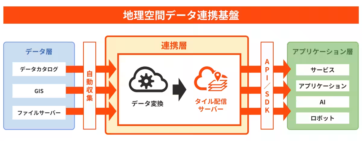
1. Overall Framework Structure: It includes an architectural diagram depicting the complete structure of the geospatial data integration framework.
2. Three-Layer Architecture: Detailed roles for the data layer, integration layer, and application layer are clarified.
3. Integration Technologies: The relationship with surrounding technologies such as spatial IDs and FIWARE for data integration is described.
4. Data Formats: Characteristics and benefits of various formats, including vector tiles and data PNG, are highlighted.
5. Open Source Utilization: The document emphasizes how the integration framework effectively combines various open-source tools such as CKAN, MapLibre GL JS, deck.gl, and Tippecanoe.
6. Case Studies: Examples from Takamatsu City with its 'My Safety Map', Yaizu City’s 'Smart Map Yaizu’, and the Ministry of Land, Infrastructure, Transport and Tourism's 'Real Estate Information Library API' are presented to illustrate practical applications of the framework.
7. Sample Specifications: The guide provides samples of specifications that organizations can publicize when procuring the geospatial data integration framework.
The Core Function in Urban OS
As stated in the third edition of the Smart City Reference Architecture, the geospatial data integration framework is described as:
>The urban OS's function is to serve as a unified data foundation for cities, essential for elements like digital twins. Particularly, as noted in the supplementary volume, this standard geospatial data integration framework is indispensable for urban OS. The first step in realizing smart cities is facilitating inter-sector data integration and visualization on this framework.
This definition establishes the framework’s role as a pivotal function in promoting data connectivity within the societal context of smart cities. Geolonia is committed to contributing to the advancement of intelligent cities through these efforts.
About Geolonia
Founded in August 2019, Geolonia operates with the mission to link the physical and digital worlds and cultivate an open and flat society. The startup is a partner of the Geospatial Information Authority of Japan and a member of the United Nations Open GIS Initiative. Geolonia provides web mapping services, location development support, and a location platform.
Representative: Takayuki Miyauchi, President & CEO
Headquarters: 22F Bunkyo Green Court Center Office, 2-28-8 Hongo, Bunkyo-ku, Tokyo
With a focus on cloud services, system development, and various data sales related to location information, Geolonia is at the forefront of shaping urban landscapes through technology.
For more information, visit their website.

Topics Consumer Technology)
【About Using Articles】
You can freely use the title and article content by linking to the page where the article is posted.
※ Images cannot be used.
【About Links】
Links are free to use.