New Geological Map Reveals Rich History of the Sea of Japan's Formation


New Geological Map in the Sea of Japan
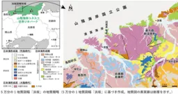
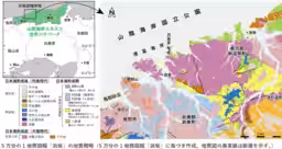
The National Institute of Advanced Industrial Science and Technology (AIST) has recently published a new geological map, "Hamasaka", representing the results of extensive geological surveys in the Hamasaka area, located between Tottori and Hyogo Prefectures. This new 1:50,000 scale geological map marks the first publication in this region in 47 years, significantly enriching the understanding of the geological history of the area known as the San'in Coast UNESCO Global Geopark.
Insights into the Sea of Japan's Formation
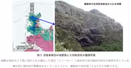
The San'in Coast UNESCO Global Geopark emphasizes the formation of the Sea of Japan as its primary theme. The Hamasaka area contains geological layers not only from the time of the Sea of Japan's formation but also from the preceding continental era and the subsequent island arc period. These layers record rapid environmental changes and significant volcanic activity, representing a region of crucial academic importance for comprehending the formation history of the Japanese archipelago. Additionally, the complexity of the region's geology, impacted by substantial fluctuations during the formation of the Sea of Japan, necessitated the development of detailed geological representations previously unachievable in older maps.
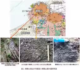
The new map synthesizes information obtained from over 400 days of concentrated field surveys alongside chemical composition analysis and age determinations. Notably, regarding the layers from the Miocene, the Northern Tottori Group, the research illustrates how the region transitioned from land to shallow and deep sea environments and back to land due to drastic environmental shifts and concurrent volcanic activities. For instance, in Mt. Sujiyama, located at the border of Tottori City and Iwami Town, volcanic ejecta from the late stage of the Sea of Japan's formation has been identified, leading to the newly designated "Sujiyama Layer", revealing records of stratigraphy that highlight the area's transitional environment.
Discoveries and Contributions
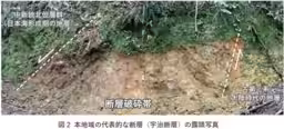
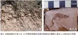
The publication of this geological map not only organizes new findings regarding the stratigraphic history and relationships between fault exposures but also clarifies the timing and distribution of fault activities in the region. Investigations revealed new sources for the "Middle Miocene Fish Fossil Group", recognized by the Geological Society of Japan, enhancing understanding of the area's extinct aquatic fauna.
Geological Features and Publications
Additionally, the map presents detailed descriptions of various geological features including the ancient granite known as "Uratomi Granite", dating back around 33 to 32 million years, which forms part of the stunning landscape of Uratomi Coast. The map compiles historical research and standardizes geological terminology, providing a reliable reference for future research initiatives.
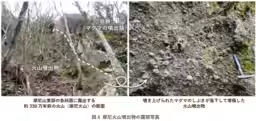
In Mt. Mani, approximately 3.3 million years ago, previously unrecognized volcanic remains have been discovered, now named the "Mani Volcano", contributing to the geological narrative of volcanic activities in the region. Furthermore, in Iwami Town, basalt flows were identified as dating back approximately 4.3 million years, now termed "Ohaeo Lava", offering new insights into the geological time scale of the area.
The geological contributions of the Hamasaka map promise support for further advancements in fields such as geology, paleobiology, and geomorphology, while also serving as a vital resource for interdisciplinary research in archaeology and history. This map is anticipated to significantly aid scientific planning for slope disaster prevention, land use strategies, and seismic risk evaluation, while enriching educational endeavors and geo-tourism initiatives, stimulating regional revitalization efforts.
Availability
The geological map can be downloaded from AIST's Geological Survey Comprehensive Center website or purchased from affiliated sales vendors, ensuring accessibility for researchers and the general public interested in the geological heritage of the San'in Coast region.
Topics Environment)

【About Using Articles】
You can freely use the title and article content by linking to the page where the article is posted.
※ Images cannot be used.
【About Links】
Links are free to use.