


Advanced AI Techniques Facilitate Land Use Analysis Using Daichi 2 Satellite Data
Revolutionizing Land Use Analysis with AI and Satellite Data
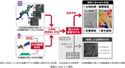
The integration of advanced AI methodologies into land use analysis is gaining momentum, particularly through the groundbreaking work by the National Institute of Advanced Industrial Science and Technology (AIST) in collaboration with the Japan Aerospace Exploration Agency (JAXA). They have successfully utilized synthetic aperture radar (SAR) data from the Daichi 2 satellite (ALOS-2) to construct a foundational model specifically designed for Japan's unique land characteristics.
Overview of the Research
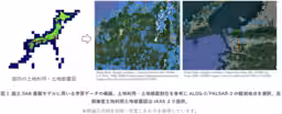
Understanding Japan's complex geography, where approximately 70% is forested, the researchers took significant measures to ensure that the data utilized for training was representative of various land use and cover types across the country. The primary objective was to address the biases present in existing datasets by creating a well-balanced training dataset that equally incorporates different land uses, such as urban areas, agricultural lands, and water bodies.
Using JAXA's high-resolution SAR data gathered continuously across Japan, the researchers conducted extensive unsupervised learning using a sophisticated AI cloud computing system, known as ABCI. The approach not only maximized the efficient use of SAR data but also facilitated the creation of a specialized model that significantly improves the accuracy of land use and cover predictions. Early results have shown substantial advancements, with estimations yielding over a 10% increase in precision compared to previous models reliant solely on randomly generated datasets.
Enhancing Accessibility to SAR Data Interpretation
A substantial challenge in the broader application of SAR technology is the high level of specialized knowledge required to decode the images produced. To tackle this barrier, the foundational model developed aims to lower the entry threshold for analyzing SAR images, thus expanding the accessibility of this advanced technology to a wider audience.
This project is rooted in the agreement between AIST and JAXA to research AI analysis methods for satellite data. The finalized outcomes are slated for presentation at the upcoming 78th Japan Remote Sensing Society Academic Conference scheduled for June 4-5, 2025.
Significance of SAR Technology
SAR technology represents a pivotal advancement in remote sensing, utilizing microwave signals to create high-resolution imagery irrespective of weather conditions or illumination. The PALSAR-2 sensor aboard the Daichi 2 satellite operates within the L-band frequency range, making it particularly effective for detecting variations in forested landscapes and monitoring disaster-prone areas in Japan and beyond. As SAR's potential realization burgeons, the necessity for cutting-edge AI implementation grows ever more critical to unlock its full capabilities.
The existing barriers hindering broader SAR utilization stem from the costs associated with large-scale computation and data acquisition. The introduction of a foundational model significantly mitigates these barriers by enabling AI models to be formulated with minimal additional learning once the base model is established. An extensive repository of over 300,000 image patches allows for diverse training, paving the way for adaptive learning techniques.
Future Directions and Applications
Moving forward, the pioneering foundation model will serve as a pivotal resource for various applications, including disaster detection and urban transformation monitoring. The goal is to enhance practical use cases while continuously assessing the model's effectiveness. Furthermore, the model aims to bridge the linguistic gap in understanding SAR data by facilitating the translation of analytical outcomes into human-understandable narratives. This could revolutionize how such data assists in decision-making processes, potentially influencing future observational tasks.
As researchers work towards refining this technology, the ultimate objective remains: to democratize access to SAR analysis, enabling a broad spectrum of professionals to engage in the valuable interpretation of satellite data. This endeavor not only promises to deepen our understanding of land use dynamics but also underscores the ever-evolving intersection of satellite technology and artificial intelligence in addressing real-world challenges.
Conclusion
The collaborative efforts between AIST and JAXA underscore a significant leap forward in the utilization of SAR data for land analysis. By making this technology more accessible and effective, they are paving the way for enhanced intelligence and foresight in managing Japan's landscapes and reacting better to natural events.
For further details, you can explore the official press release here.


Topics Other)


【About Using Articles】
You can freely use the title and article content by linking to the page where the article is posted.
※ Images cannot be used.
【About Links】
Links are free to use.