
New Geological Map of Izu-Oshima Volcano Unveils Vital Eruption Insights


New Geological Map of Izu-Oshima Volcano Unveiled
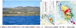
The National Institute of Advanced Industrial Science and Technology (AIST) has released the updated geological map of Izu-Oshima Volcano, titled "Izu-Oshima Volcano Geological Map (2nd Edition)," in collaboration with the University of Tokyo's Earthquake Research Institute. This new edition incorporates extensive research conducted since the release of the first edition in 1998, effectively synthesizing advances in the understanding of volcanic activity.
The updated map provides a seamless depiction of the geological history of Izu-Oshima Volcano, illustrating how and where eruptions shaped this active volcano. This groundbreaking representation combines land and underwater data, establishing it as the world's first comprehensive geological map to connect these two realms.
Izu-Oshima Volcano is recognized as one of Japan's active volcanoes, with a pattern of eruptions occurring approximately every 100 to 150 years. Major eruptions have been documented, including a significant eruption in 1986 that led to islandwide evacuation. The geological map serves as an essential resource for understanding these hazards.
The bulk of Izu-Oshima's volcanic structure is submerged beneath the sea, necessitating the gathering of comprehensive information about both onshore and offshore volcanic activity for eruption assessment. This geological map was developed using high-resolution topographic data and detailed geological information collected since 1998. New research findings have improved the accuracy of vent locations, making it easier to visualize the relationship between volcanic output and its sources.
Moreover, for areas at risk during eruptions, extensive geological surveys were conducted in coastal regions and surrounding waters to characterize vent distributions and volcanic deposits. High-resolution surveys used small boats equipped with sounding devices to collect detailed topographic data, while low-frequency sound pulses were employed to assess geological layers below the seafloor.
Data obtained through these investigations facilitated the collection of seabed samples. Underwater drones and cameras contributed to understanding the underwater geological features, confirming the existence of multiple side volcanoes aligned in a north-west to south-east direction beneath the coastal seabed, which aligns with findings on land. This yields significant insights regarding potential underwater eruptions and their impact on coastal areas.
The final geological map encompasses not only the terrestrial features but also the underwater volcanic structure, alongside the Izu eastern volcanic group. This consolidated view enhances our understanding of the entire Izu-Oshima Volcano system. AIST remains committed to advancing research related to the eruption history of this site and furthering the understanding of its magma supply systems, especially concerning side volcanoes.
The Izu-Oshima Volcano Geological Map is not only foundational for academic research but is also poised to contribute to disaster risk reduction by informing hazard mapping and evacuation planning. Additionally, it is expected to serve as a vital educational resource in geoparks and national parks for natural interpretation.
For access to the geological map, it can be downloaded from the AIST Geological Survey Comprehensive Center website here and is also available for purchase through affiliated vendors here. The published map is a cornerstone for future research and practical application in volcanic disaster mitigation.

Topics Other)


【About Using Articles】
You can freely use the title and article content by linking to the page where the article is posted.
※ Images cannot be used.
【About Links】
Links are free to use.