


Kokusai Kogyo Updates Free Bois Service for Disaster Response
Kokusai Kogyo Enhancements to Bois
Kokusai Kogyo Co., Ltd., headquartered in Shinjuku, Tokyo, has made significant updates to its free disaster response service, Bois, aimed at streamlining the analysis and identification of aerial photographs captured during disaster investigations. This upgrade was made public on April 2026, at the company's corporate website, improving user interface (UI) for better quantity management of images.
Background and Challenges
In recent years, the increasing frequency and scale of disasters have led to a substantial rise in the number of aerial images captured per event. This escalation has resulted in a daunting challenge: efficiently locating specific areas amidst an overwhelming amount of data. Users voiced their need for enhanced functionality, expressing desires to quickly select desired images from a large pool and to concurrently reference maps with photographs for improved clarity.
Key Features of the Update
The latest update focuses on enhancing visibility and searchability, implementing several new features:
1. Upgraded Background Maps: The service now supports overlay with geospatial maps from the Geospatial Information Authority of Japan (GSI). This development boosts visibility of crucial infrastructures such as roads, rivers, and buildings while aiding in precise situational understanding of affected areas.
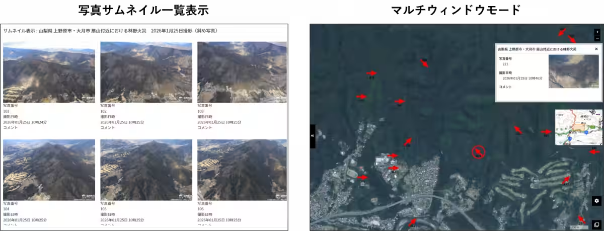
2. Thumbnail Display Option: Users can now view a comprehensive list of images in thumbnail form, allowing for intuitive image navigation. This function facilitates easy visual selection of photos, enabling swift access to the corresponding shooting locations on the map, significantly cutting down extraction times.
3. Multi-Window Mode: A new split-screen option lets users simultaneously view maps, aerial images, and relevant zone outlines on one screen. This ensures that the map is unobscured by any photographs, allowing for real-time assessment of both regional relationships and detailed disaster conditions.
4. Optimized Symbol Display: The icons indicating shooting locations have been updated to arrow formats, showing direction intuitively. By emphasizing the relevant icon while viewing a photo, the system minimizes location misinterpretations.
5. Continuous Browsing and Map Synchronization: Users can now smoothly switch between images using clicks or directional keys. The ability to highlight the map position corresponding to displayed images eliminates confusion about current locations.
More details about the site and its functions can be found in the service description.
Future Outlook
Kokusai Kogyo is committed to refining the service further by incorporating user feedback, striving to offer an easily navigable information viewing platform. The company aims to contribute to rapid situational understanding and the realization of a safer society through the utilization of spatial information during disasters.
About Free Version Bois
Launched in August 2020, the free version of Bois provides access to a portion of the disaster management supporting tool without requiring specialized software or registration. Users can simply click on plotted maps to assess real-time disaster situations. The company has established a rapid data release system supported by emergency aerial photography from three national bases.
For more information on image data usage conditions, please refer to this link.
Official X Account for Timely Updates
In times of major disasters, Kokusai Kogyo publishes aerial photographs on its website and simultaneously shares updates through its official X (previously Twitter) account. For prompt information on the latest releases, following the official account is highly encouraged as a tool for quick situational awareness and data collection. You can find the official Kokusai Kogyo X account here.
Premium Service for Corporations: Bois/Disaster Information Service
Kokusai Kogyo also provides a paid service designed for businesses, allowing users to pre-register locations and suppliers. This service enables immediate identification of disaster-related risks and automates real-time matching of disaster information to pre-registered sites, significantly aiding rapid corporate decision-making. More about this can be found here.


Topics Other)


【About Using Articles】
You can freely use the title and article content by linking to the page where the article is posted.
※ Images cannot be used.
【About Links】
Links are free to use.