Analyzing the Shift in Heavy Rainfall Patterns Over 40 Years for Effective Flood Mitigation Strategies


Overview
In 2018, the Climate Change Adaptation Act was enacted in Japan, setting a target for local governments to develop climate change adaptation plans. These plans are essential for preparing society for the anticipated impacts of climate change, including increasing flood risks, which have become an urgent issue. However, predicting when floods will occur is challenging, leaving local governments with insufficient data to create effective adaptation strategies. To formulate scientific and practical climate change adaptations, a solid foundation based on scientific evidence is required.
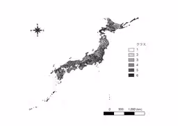
Dr. Takeshi Osawa, an associate professor at Tokyo Metropolitan University, collaborated with Gen Sakurai, a senior researcher at the National Agriculture and Food Research Organization, to classify municipalities across Japan into six distinct categories using long-term observational and statistical data. This classification is based on historical rainfall trends and current land use, helping to identify municipalities vulnerable to flood damage and those with resilient land use. This classification will be key in developing tailored adaptation measures for each region.
This groundbreaking research was published in the journal Water Research on May 3. It is part of a broader initiative supported by the Environment Research and Development Program and the Cabinet Office’s Strategic Innovation Creation Program (SIP), focusing on developing smart infrastructure management systems.
Key Points
- - Preparing for the increasing impact of floods is a vital component of climate change adaptation.
- - A classification of municipalities into six categories has been developed based on data from the last 40 years of rainfall and current land use.
- - The classification can serve as foundational information for local governments in formulating climate change adaptation strategies.
Background to the Research
The Climate Change Adaptation Act mandates that the national government and local authorities formulate adaptation plans. These plans aim to prepare for some changes due to climate change and to develop a society capable of utilizing these changes effectively. As flooding issues intensify due to climate change, developing strategies to mitigate flooding risks is crucial.
Traditionally, flood risk management has relied on structural measures, such as dams and levees. However, there is growing interest in non-structural measures using ecosystem-based disaster risk reduction (Eco-DRR) approaches. While structural measures provide reliable protection, the high costs limit their widespread implementation. Conversely, green infrastructure (GI), though possibly less effective in some scenarios, offers benefits beyond flood protection, including biodiversity preservation and socioeconomic advantages.
A smart approach combines structural measures with green infrastructure, specifically targeting areas forecasted to experience increased flooding due to climate change. However, predicting these at-risk areas can be complex, and the effectiveness of green infrastructure can vary depending on local ecosystems, necessitating precise deployments for optimal benefits. Identifying areas most likely to face increased flooding risk and ensuring an effective mix of structural and non-structural strategies are crucial to successful adaptation.
Research Details
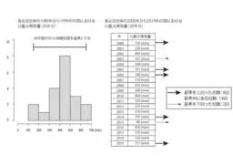
In this study, rainfall data, statistical information, and land use data from the past 40 years were analyzed to propose a basic guideline for local governments on climate change adaptation strategies regarding flooding. First, the researchers used flood statistics to analyze municipalities that experienced human and economic losses from floods between 2010 and 2019, identifying trends correlating heavy rainfall with increased flood occurrences. This analysis helps establish a measurable indicator: the maximum daily rainfall for any given year, which correlates with flood risk.
Next, the study compared rainfall data from 1980 to 1999 with data from 2000 to 2019, focusing on maximum daily rainfall variations to assess how trends had shifted over the years. Municipalities that showed increased maximum daily rainfall were judged to have higher flood risks, indicating a need for enhanced flood management strategies.
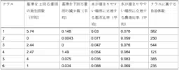
Using statistical models, the research confirmed findings from earlier studies that urban areas prone to flooding tend to be located in water catchment zones, while agricultural land under similar conditions provides protective benefits as green infrastructure. By analyzing the proportion of urban areas located in flood-prone zones compared to agricultural land, the researchers could gauge municipalities' vulnerabilities and resiliencies to flooding.
Based on these findings, the researchers successfully classified 6 distinct categories of municipalities using non-hierarchical clustering methods (k-means). Each class possesses unique attributes regarding rainfall conditions and land utilization, offering insights into appropriate climate change adaptation strategies tailored to individual municipal characteristics.
Significance and Potential Impact
While predicting the effects of climate change carries inherent uncertainties, it's imperative to prepare viable adaptation strategies and implement them effectively. This study provides a foundational guideline for local governments struggling to develop effective flood adaptation strategies, encouraging them to take necessary first steps. Additionally, municipalities within the same class can collaborate to refine their flood management and adaptation processes, fostering a network of cooperation and support in addressing shared climate challenges.

Topics Policy & Public Interest)

【About Using Articles】
You can freely use the title and article content by linking to the page where the article is posted.
※ Images cannot be used.
【About Links】
Links are free to use.