
3D Visualization of Weak Layers Beneath Saitama's Major Urban Areas


3D Visualization of Weak Geological Layers in Saitama
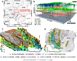
The National Institute of Advanced Industrial Science and Technology (AIST) has recently unveiled a comprehensive 3D geological map of Saitama's southeastern region, highlighting the distribution of soft geological layers beneath major urban areas, including Saitama Shintoshin. This area is significant both administratively and commercially, located adjacent to Tokyo and experiencing rapid urbanization. Given the risk of the Tokyo metropolitan earthquake, which could lead to severe damage, this research is particularly timely.
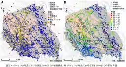
By collaborating with the Saitama Environmental Science International Center, AIST conducted an extensive analysis of over 10,000 borehole datasets, revealing the geological structure beneath Saitama Prefecture's southeastern lowlands, extending several tens of meters underground. The research detailed the 3D distribution of soft alluvial layers, known to fill ancient valleys, and found surprising results where even elevated plateaus were shown to harbor similar soft strata. These weak layers can amplify seismic shaking and contribute to ground subsidence, making the geological map a crucial tool for hazard mapping, urban planning, and civil engineering.
Understanding Saitama's Lowlands
The lowlands in southeastern Saitama primarily contain alluvial layers formed during the last ice age approximately 20,000 years ago. Traditionally, these soft layers were known to fill valleys, but recent in-depth analysis allowed a detailed presentation of their 3D distribution patterns. Analyzing the N-value, which indicates soil strength, revealed regional nuances: in the Arakawa lowland, primarily composed of mud layers, there was a moderate presence of sand layers, yielding an average N-value around 10 up to a depth of 30 meters. Meanwhile, the Nakagawa lowland predominantly featured mud layers with average N-values below 5, indicating extremely soft ground conditions.
Contrary to common assumptions that plateaus possess better ground conditions, the analysis uncovered soft layers in the underground of the Omiya Plateau, situated between the Arakawa and Nakagawa lowlands. These layers date back around 140,000 years to a previous ice age, exhibiting a 3D distribution that mimics the ancient valleys they fill. Even in areas near Saitama City’s Urawa district, where the plateau typically suggests stability, average N-values remained around 10, parallel to the lowlands.
Implications and Future Applications
The creation of this detailed geological map opens numerous possibilities for practical application. Urban planners and civil engineers can utilize the information to inform designs, ensuring infrastructure is resilient to seismic hazards. Moreover, the data serves as a basis for hazard mappings, enhancing safety measures against potential earthquakes.
The geological maps created from borehole data facilitate a visual understanding of the subsurface structure through various representations such as flat plan views, cross-sections, and 3D models. This release is the third in the series focusing on urban geological maps, following prior releases for the Tokyo metropolitan area and northern Chiba Prefecture.
To access the geological map, visit the official webpage at AIST Urban Geological Map.
Glossary of Terms
- - Urban Geological Maps: These maps incorporate data from borehole assessments to visualize subsurface geological structure in a three-dimensional manner.
- - Lowlands: Refers to flat, low-elevation areas often shaped by river or coastal sedimentation.
- - Alluvial Layers: Geological strata deposited over thousands of years by rivers, commonly found in lowland areas and characterized by their softness due to high moisture content.
- - Plateaus: Elevated flat areas formed through geological upheaval, often harboring older strata compared to surrounding lowlands.
Conclusion
The newly published geological map is not only a significant scientific contribution but also a vital resource for urban safety and planning in one of Japan’s most densely populated areas. As Saitama continues to grow, understanding its geological foundation will become increasingly crucial for ensuring the safety and resilience of its infrastructure.
Topics Other)
【About Using Articles】
You can freely use the title and article content by linking to the page where the article is posted.
※ Images cannot be used.
【About Links】
Links are free to use.