


Revolutionizing Coastal Monitoring with Hyperspectral Technology from Space
Unveiling Coastal Ecosystems from Space
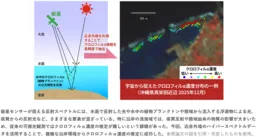
In an innovative step forward for environmental monitoring, a research team from the National Institute of Advanced Industrial Science and Technology (AIST) in Japan has developed a groundbreaking method to estimate chlorophyll-alpha concentrations in coastal waters using data from the Hyperspectral Imager Suite (HISUI) onboard the International Space Station (ISS). The new technique integrates advanced data mining techniques to analyze hyperspectral data, marking a significant leap in environmental monitoring for coastal ecosystems.
The Need for Effective Monitoring
Coastal areas, while often visually beautiful with vibrant coral reefs, are increasingly threatened by human activities such as development and tourism. These activities can lead to significant environmental degradation, making it crucial to monitor ecological changes effectively. Traditional methods of monitoring focused on surface water conditions often struggled to provide accurate assessments in complex coastal environments due to interference from land-derived substances and seabed reflections. Therefore, a need arose for more precise, efficient techniques to assess these crucial ecosystems objectively and continuously.
Breakthrough Methodology
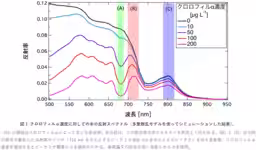
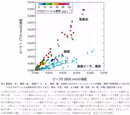
The research led by Satoru Yamamoto and his colleagues identified unique spectral patterns that occur in the near-infrared wavelengths (710 nm and 800 nm) which correlate with chlorophyll-alpha concentrations. By applying data mining techniques to HISUI's hyperspectral data, they were able to detect these double peaks clearly for the first time, providing a reliable indicator of chlorophyll-alpha in coastal areas.
Data Collection and Findings
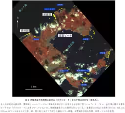
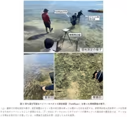
To validate their findings, the team conducted in-situ spectral measurements and chlorophyll assessments at various coastal sites in Okinawa. The correlation between the double peaks observed in hyperspectral data and actual chlorophyll-alpha concentrations was robust. In areas where double peaks were concentrated, a rich biodiversity with active life forms was confirmed. Conversely, locations without these peaks indicated significantly lower biodiversity and chlorophyll levels. This stark contrast demonstrated the effectiveness of the new method in monitoring coastal health from space.
Implications for Coastal Ecosystems
This innovative technique holds immense promise for long-term monitoring of coastal ecosystems. The dual peaks serve as reliable indicators to track chlorophyll concentrations, enabling researchers and policymakers to react more promptly to environmental changes. Additionally, this methodology may facilitate the identification of indicators for harmful algal blooms, thus helping in better managing coastal waters and protecting marine life.
Future Developments
Moving forward, the researchers plan to enhance their approach by integrating the drone-based hyperspectral sensors, which will allow for even finer spatial resolution and higher observation frequency. This dual approach combining satellites and drones could enable a comprehensive monitoring solution, further advancing the understanding and protection of our coastal ecosystems.
The full details of their research can be found in the forthcoming publication in the "Journal of Geophysical Research: Biogeosciences," expected to shed further light on this revolutionary monitoring technology. As environmental challenges continue to evolve, this hyperspectral monitoring technique may play a pivotal role in maintaining the health of our vital coastal habitats.

Topics Other)


【About Using Articles】
You can freely use the title and article content by linking to the page where the article is posted.
※ Images cannot be used.
【About Links】
Links are free to use.