


The Release of the Revised Geological Map of the Keihanshin Area: A Comprehensive Study
Release of the Revised Geological Map
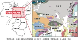
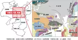
The National Institute of Advanced Industrial Science and Technology, known as AIST, has just released a new edition of the geological map for the Kyoto and Osaka area, which covers the broader Keihanshin urban sphere, the second edition since its inception in 1986. This substantial update comes 40 years after the original release and boasts a compilation of diverse strata and rock distributions in northern Kinki, including the Keihanshin area. It reflects geological formations developed under various conditions from the late Paleozoic era—approximately 400 million years ago—to the present.
In preparing this comprehensive geological map, over 150 days of field geological surveys were conducted, utilizing the latest geoscientific information and knowledge gathered from the late 1980s up to now. The revisions resulted in the doubling of legend items, from 52 in the first edition to 113 in the second, illustrating a significant enhancement in the detail of geological classification. Consequently, this updated map serves as a crucial research outcome for understanding the geological context of the Keihanshin urban area.
Home to approximately 13 million residents across its prefectural capitals and surrounding municipalities, the Keihanshin region is characterized by a dense population and complex transportation networks. It also poses significant risks due to active fault lines, including the Rokko-Awaji fault system responsible for the Southern Hyogo Earthquake, as well as the Arima-Takatsuki fault that is believed to have caused the 1596 Keicho Fushimi Earthquake. Preparing for potential disasters is an urgent societal necessity, making this geological map an invaluable resource. The map distinguishes between confirmed and estimated active faults while incorporating gravity analysis to overlay isostatic anomalies, enabling insights into the subterranean geological structures.
This information plays a fundamental role in urban infrastructure development within the region. Furthermore, with historical cities like Kyoto and Nara, scenic spots along Lake Biwa, and modern urban centers like Osaka and Kobe, the area draws a wealth of domestic and international tourists. Consequently, the geological map is expected to contribute significantly to both disaster prevention and the tourism industry by serving as a valuable geological reference.
For those interested, the updated map became accessible on April 16 via the AIST Geological Survey Comprehensive Center's website and is also available for purchase through affiliated vendors.
Additional Context and Definitions
- - Geological Map: A map illustrating the distribution of strata and rocks at the Earth's surface, stripped of vegetation and soil.
- - Active Fault: A fault that has shown repeated activity in recent geological periods and has potential for future movement.
- - Isostatic Anomaly: Lines connecting points of equal gravitational strength, aiding the understanding of underground geological distributions.
This revised geological map is poised to enhance our understanding of the area's geology and serve as a foundation for future studies and initiatives aimed at bolstering safety and local development.
Topics Other)


【About Using Articles】
You can freely use the title and article content by linking to the page where the article is posted.
※ Images cannot be used.
【About Links】
Links are free to use.