


Geolonia and Geotechnologies Launch Outdoor Event Measurement Service
Introduction
In a groundbreaking collaboration, Geolonia, a Tokyo-based startup specializing in location-based services, and Geotechnologies, a longstanding provider of digital mapping solutions, have jointly unveiled an unprecedented service aimed at measuring the effectiveness of outdoor events nationwide.
The Need for Measurement
Outdoor events have become a vital part of local community engagement and tourism promotion efforts across Japan. They play a significant role in regional revitalization, particularly in recent years where both public and private sectors have intensified their collaborative efforts to boost local economies. However, despite their importance, measuring the impact of these events has been challenging due to the free movement and dispersed nature of attendees, making it difficult to quantitatively assess visitor numbers, dwell times, and economic ripple effects on the region.
Unique Measurement Approach
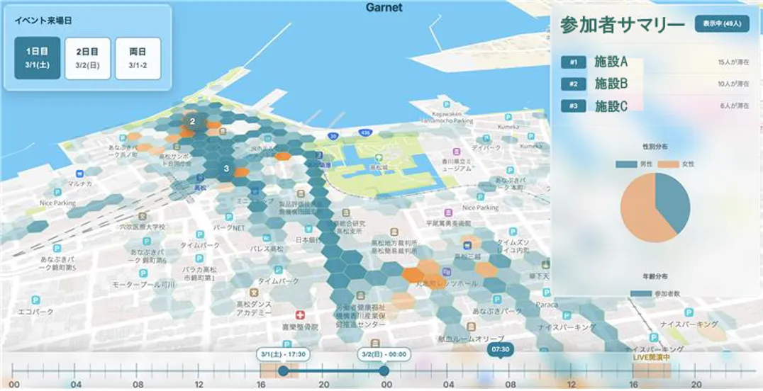
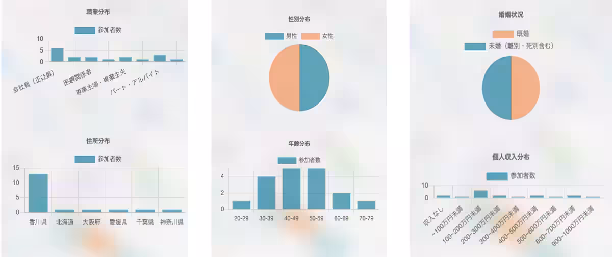
The newly launched service utilizes anonymized pedestrian flow data, labeled as "Geo-People," combined with a location-based survey tool known as "Geo-Research." By adopting a unique methodology that harnesses these two sources of data, events can gain a clearer view of attendee behavior, satisfaction levels, and regional economic impacts, which were difficult to measure accurately before.
Maximizing Local Event Value
In the pursuit of sustainable regional revitalization, it is crucial to visualize data-driven evidence regarding the effects and impacts of local outdoor events. Geolonia and Geotechnologies have risen to this challenge by creating a service that objectively visualizes event outcomes, thus enabling municipalities and businesses to base their strategies on concrete data. This will facilitate informed planning, execution, and improvement of future events, driving economic benefits for local communities.
Service Functions
With this service, Geotechnologies leverages its proprietary "Geo-People" data to conduct detailed analyses on audience behavior before and after events. This allows organizers to track when and where attendees came from, their movements during the event, and the extent of the positive effects on the surrounding area.
Additionally, the "Geo-Research" tool gathers qualitative feedback on the event experience, such as satisfaction levels and intentions to revisit, thereby encapsulating genuine attendee sentiments.
These layers of data are integrated through Geolonia's visualization technology, providing a dashboard that municipalities and promotional entities can access. This system ensures users can grasp nuances of event effectiveness through intuitive and quantifiable insights.
Anticipated Outcomes and Future Prospects
This initiative leads to the ability to portray the draw of outdoor events and their subsequent economic contributions through objective data analytics. By evaluating aspects such as attendee volume, time spent, and satisfaction, municipalities and businesses can gain multi-faceted insights into the value these events bring to the community.
Ultimately, this enables effective planning and leads to the continual enhancement of event value through data-driven decisions. By promoting data-driven event management, Geolonia and Geotechnologies are poised to contribute to the evolution of entertainment industries while also bolstering local community growth.
About Geotechnologies
Establishing itself in 1994, Geotechnologies has steadfastly provided digital mapping solutions. Its offerings have evolved to include everything from the first-ever domestic i-mode mapping application to advanced maps essential for autonomous driving technologies. Their apps are gaining traction with users, enabling real-time insights into urban mobility.
Corporate Website: Geotechnologies
About Geolonia
Founded in August 2019, Geolonia is recognized for its innovative location-based solutions. As a member of the UN Open GIS Initiative and partner of the Geospatial Information Authority of Japan, the company aims to foster smart city architectures.
Corporate Website: Geolonia


Topics Consumer Products & Retail)


【About Using Articles】
You can freely use the title and article content by linking to the page where the article is posted.
※ Images cannot be used.
【About Links】
Links are free to use.