


New Geological Map of the Tanakura Fault Zone Released after 30 Years in Ibaraki Prefecture
New Geological Map of the Tanakura Fault Zone
In a significant development for geological research and regional safety, the Geological Survey of Japan has published a new 1:50,000 scale geological map of the Daigo area in northern Ibaraki Prefecture. This release marks the first such publication in thirty years, presenting detailed geological information pertinent to one of Japan's major fault lines—the Tanakura Fault Zone.
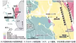
The Tanakura Fault Zone, stretching north-northwest to south-southeast from Hitachiota City to Tanakra Town in Fukushima Prefecture, is critically significant for understanding seismic activities in the region. This newly released map offers comprehensive insights gathered over 300 days of careful geological surveying, including rock chemical analyses, micropaleontological extractions, and dating assessments. The results have led to a refined understanding of the major geological formations in this area, including the Jurassic-age Ashio belt and the Cretaceous-age Abukuma belt, both surrounded by the Tanakura Fault Zone itself.
This geological map serves a dual purpose; it not only contributes foundational data for academic research but also plays a crucial role in disaster prevention strategies. As the Tanakura fault is known for its seismic activity, this map is expected to be a vital tool for better understanding land subsidence, uplift movements, and rotations that arise from fault activities. The accompanying data elucidates the geological history of the Tanakura Fault, revealing how these geological processes shaped the landscape over time.
The significance of this map extends beyond academia. Local landmarks, such as the picturesque Fukuroda Falls and the breathtaking Ryujin Gorge with the Ryujin Suspension Bridge, are also mapped. This offers a unique opportunity for promoting Ibaraki Prefecture as a destination for both tourism and geological education, aligning with broader regional development goals.
Researchers involved in this project include Jun Hosoi from the Geological Information Research Department at the National Institute of Advanced Industrial Science and Technology (AIST), alongside colleagues such as Kun Nakae and Hiro Takahashi. Together, they have contributed comprehensive research findings which link geological hazards to local developments, thus promoting public interest and safety.
This detailed geological map and its accompanying data will be available for download starting January 26 from the AIST Geological Survey’s official website. Furthermore, it can also be purchased through licensed distributors, enabling wide accessibility for both experts and the general public interested in understanding the geological features of this significant region.
This initiative not only enhances academic knowledge but also serves as an essential resource for disaster risk reduction and local community engagement, fortifying ties between science and public interest in Ibaraki Prefecture.
For further details regarding these publications, the following papers may provide additional insights:
- - Published in Tectonics: "Rotated transtensional basins formed during back-arc spreading in Japan: Simultaneous rapid tectonic rotation and basin subsidence" by Jun Hosoi and colleagues.
- - Published in Progress in Earth and Planetary Science: "Miocene dextral movement of the Tanakura fault zone, Japan: strike-slip fault inversion due to arc-arc collision" by Jun Hosoi and collaborators.
In conclusion, the new geological map not only represents years of diligent research but is also an indispensable asset for those seeking to understand and utilize the geological intricacies of the Ibaraki region, ensuring a safer future for its residents and visitors alike.
Topics Other)


【About Using Articles】
You can freely use the title and article content by linking to the page where the article is posted.
※ Images cannot be used.
【About Links】
Links are free to use.