


High-Resolution 3D Data Unveiled from the Noto Peninsula Earthquake for Education and Research Use
High-Resolution 3D Data from Noto Peninsula Earthquake
The recent devastating Noto Peninsula Earthquake, which occurred in Reiwa 6 (2024), has prompted significant research efforts across Japan. A collaborative initiative involving experts from several universities, including Okayama University, Ritsumeikan University, and Kanazawa University, has produced high-resolution 3D data reflecting the changes to the topography caused by this disaster. This data is poised to serve dual purposes: aiding in foundational research in geomorphology and contributing to educational resources focused on disaster prevention and environmental education.
The Research and Its Importance
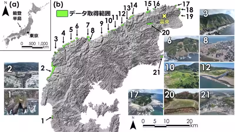
The research team, featuring esteemed professors and researchers from various institutions, utilized advanced drone technology to gather precise topographic measurements in regions impacted by the seismic event. By concentrating on areas where coastal topographies have shifted dramatically, they aimed to create a vital archive of information that can be employed not only for academic research but also as educational materials in geography and earth science.
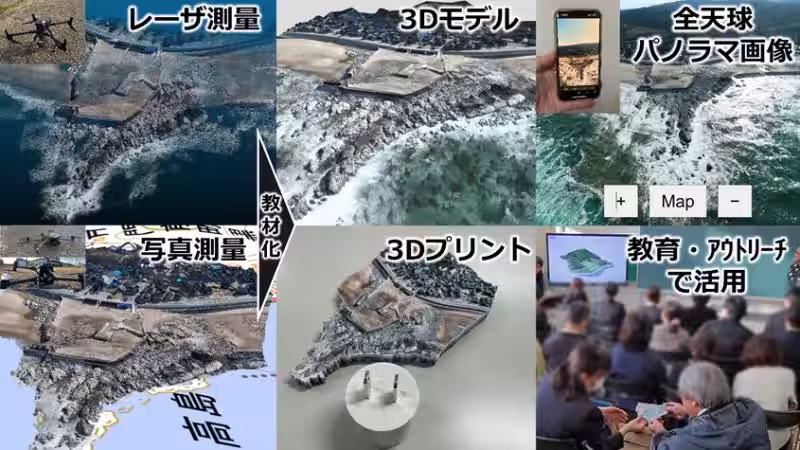
In addition to collecting three-dimensional data, this team has developed digital resources, including 3D models, panoramic images, and materials suitable for 3D printing. These resources are now publicly available on the web, making them accessible for educational purposes (shown in Figure 1). Educators and students alike can leverage this information to enhance their understanding of geological changes due to natural disasters.
Planned Educational Implementations
In November 2024, a training program for elementary school teachers in Wajima City is planned, utilizing the generated educational materials. This initiative aims to equip teachers with effective methodologies for incorporating environmental and disaster education into their classrooms. Feedback from the training will also assist in evaluating the materials' usability and potential for wider application.
Publication of Research
The results of this comprehensive research project were published in the international journal, Journal of Disaster Research, on August 1, 2025. The article titled "High-definition topographic archiving and educational applications in regions affected by the 2024 Noto Peninsula Earthquake" is authored by a team of dedicated scholars committed to disaster science. This initiative is supported by grants from various research foundations, aiming to enhance disaster preparedness and resilience.
Conclusion
The availability of high-resolution 3D data from the Noto Peninsula Earthquake marks a significant stride in both research and education. Not only does it pave the way for further academic inquiry into geomorphological processes, but it also stands as a vital resource in educating the next generation about the importance of disaster awareness and response. With such innovative approaches, the academic community seeks to foster a well-informed society capable of understanding and mitigating the impacts of natural disasters.
For more detailed insights into the research and access to the published article, please visit Okayama University's official site.


Topics Other)


【About Using Articles】
You can freely use the title and article content by linking to the page where the article is posted.
※ Images cannot be used.
【About Links】
Links are free to use.