
Space Shift Launches Beta Version of Satellite Data Analysis Tool for Generative AI Services


Space Shift Introduces Its Beta Version Tool for Satellite Data Analysis
In a groundbreaking move, Space Shift, Inc., headquartered in Tokyo, has launched a beta version of its satellite data analysis tool designed specifically for generative AI services. This innovative tool represents the company's ongoing commitment to integrating advanced AI capabilities into the analysis of satellite data, providing a seamless experience for users across various sectors, including governments, municipalities, private enterprises, and individuals.
Background
For some time, Space Shift has been dedicated to developing AI solutions for satellite data analysis. With the growing accessibility of generative AI services, the company has focused on creating tools that harness its powerful AI alongside these emerging technologies. As part of this effort, the introduction of the beta version marks an important milestone, allowing users to utilize satellite data in unprecedented ways.
Overview of the Beta Version Tool
The beta tool developed by Space Shift allows users to seamlessly connect with existing generative AI services, such as Claude from Anthropic. This integration enables users to instruct the AI through natural language to analyze satellite data, drastically simplifying the user experience. One of the key features of this tool is its ability to automatically compile analysis results into comprehensive reports, allowing users to engage in further investigation and analysis as needed.
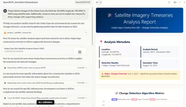
The tool specifically incorporates the 'Sentinel-1 Time Series Change Detection Algorithm,' a sophisticated technology developed and operated by Space Shift. Through this functionality, users can automatically retrieve satellite data pertaining to specific locations, analyze the data to identify temporal changes, and provide the corresponding time of detected changes back to the generative AI service for further interpretation.
Practical Usage Examples
Users can refer to various practical applications of the tool on the following URLs:
- - Example (Osaka Expo) Japanese: Detecting Changes at Osaka Expo
- - Example (Osaka Expo) English: Detecting Changes at Osaka Expo
- - Example (Gaza Strip) Japanese: Detecting Changes in Gaza Strip
- - Example (Gaza Strip) English: Detecting Changes in Gaza Strip
Users can provide instructions referencing locations using GPS coordinates, ensuring the service operates effectively by relying on the specific latitude and longitude.
How to Use the Beta Tool
The beta tool is available for free, regardless of utilization levels. It operates effectively with the Connector functionality of Claude Pro (paid version) and is also compatible with any service that offers similar connectivity (MCP, Model Context Protocol). Upon explicit instructions to analyze satellite data, the beta tool will activate, requiring details such as the subject location and timeframe.
Interested users can register for the beta tool through the following link to gain access to instructional videos and necessary information: Beta Tool Registration
Exclusive Benefits for SateBiz Partners
While the beta tool is free for general use, it comes with a maximum analysis period of six months. However, members of SateBiz, which Space Shift actively promotes, will enjoy an extended maximum analysis period of one year. Additional information will be provided to partner companies separately, and those interested in joining SateBiz can inquire here: SateBiz Inquiry
Important Notices
The beta tool is currently in its testing phase, which means it may be interrupted or subject to changes without prior notification. Users must acknowledge the risks of entering confidential information and proceed at their discretion and responsibility. While the tool itself is free to use, any associated costs arising from the utilization of underlying generative AI services will be borne by the user.
Future Developments
This beta tool currently supports only the 'Sentinel-1 Time Series Change Detection Algorithm,' but Space Shift plans to broaden its offerings. Future versions will integrate various algorithms and deep learning models to expand user capabilities further.
About Space Shift
With the mission “Sense the Unseen from Orbit,” Space Shift is focused on developing software that leverages AI to analyze data obtained from Earth observation satellites. Through these technologies, the company aims to facilitate the sustainable use of satellite data across multiple fields such as infrastructure management, disaster risk reduction, agricultural monitoring, and environmental conservation, contributing towards achieving a sustainable society.
Topics Consumer Technology)
【About Using Articles】
You can freely use the title and article content by linking to the page where the article is posted.
※ Images cannot be used.
【About Links】
Links are free to use.