


Geotechnologies Launches Open Data for AI Research in Traffic Safety and Urban Planning
Geotechnologies Introduces Open Data for AI in Traffic Safety and Urban Planning
In a significant step towards enhancing traffic safety and urban planning, Geotechnologies Inc., headquartered in Bunkyo City, Tokyo, has announced the launch of open data aimed at advancing AI research. The company has made available two key datasets: the "Road Sign Classification Data" and the "Sidewalk Safety Evaluation Data," both of which can be downloaded at no charge from the G Spatial Information Center.
Overview of the Open Data
The released datasets include detailed information to assist in AI research and development, particularly in the fields of transportation safety and urban planning. The data aims to fuel innovations that contribute to a safer society.
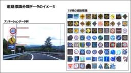
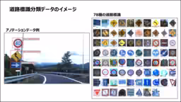
Road Sign Classification Data
This dataset consists of images extracted from nationwide driving surveys, categorized into 78 distinct types of road signs, including stop signs and no-turn signs, and accompanied by annotation data. This classification is particularly noteworthy as it aligns with Japanese traffic regulations, offering a more granular approach than existing international datasets, which often treat signs collectively. By providing categorized data, Geotechnologies anticipates applications primarily in autonomous driving and advanced driver-assistance systems, enabling better image recognition through AI.
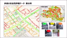
Sidewalk Safety Evaluation Data
The Sidewalk Safety Evaluation Data is unique within Japan as it assesses the risks associated with sidewalks based on their independence and potential hazards from vehicular contact. This evaluation, rated on a scale of five, allows for the identification of perilous areas, enhancing the development of transportation safety measures and urban planning strategies. Geotechnologies has released sidewalk safety assessments covering the entire Bunkyo area, furthering the goal of promoting safer walking environments.
Enhancing AI Utilization
With the rapid evolution of AI applications in transportation safety and urban planning, the necessity for high-quality, accessible training data is increasingly acknowledged. Traditional datasets from abroad often fail to address Japan's specific road conditions, necessitating significant investment of time and resources from local companies and research institutions to develop their own training datasets.
Geotechnologies, with nearly 30 years in the field of map development, has curated a massive trove of unique data, including over 4 billion images from physical surveys. By releasing portions of this data as open datasets, the company aims to facilitate AI research and development in academic and research institutions focusing on transportation safety, thereby accelerating innovations that yield new values and business opportunities.
Contribution to Open Data Community
To further engage with the open data community, representatives from Geotechnologies will present at the upcoming FOSS4G2025JAPAN conference, which will take place on October 11-12, 2025. The talk, titled "The First Step in Contributing to the Open Data Community,” will be led by Yuuto Kita from Geotechnologies’ Digital GIS Development R&D unit.
Official Conference Website: FOSS4G2025JAPAN
About Geotechnologies Inc.
Founded in 1994, Geotechnologies has consistently provided digital maps and software solutions, including the first Japanese i-mode maps and a range of navigation solutions. The company has also developed applications such as "Torima," a point collection app that offers real-time insights into human mobility and related behaviors. By leveraging vast datasets and cutting-edge technology, Geotechnologies aims to provide critical insights that contribute towards a more comfortable and sustainable world.
Head Office: 2-28-8 Hongo Komagome, Bunkyo, Tokyo
CEO: Yoichiro Yatsuken
Established: May 1, 1994
Business Scope: Automotive Business, Enterprise Business, Marketing Business, Consumer Business
Corporate Website: Geotechnologies
Topics Consumer Products & Retail)


【About Using Articles】
You can freely use the title and article content by linking to the page where the article is posted.
※ Images cannot be used.
【About Links】
Links are free to use.