


Geotechnologies Unveils Innovative MapFan Features for Efficient Mapping Needs
Geotechnologies Launches New Features for MapFan
Geotechnologies, a Tokyo-based company with approximately 3 million MapFan members, has just introduced two compelling features to its map search platform: the 'External Printing Beta' and the 'Drawing Map Beta.' These new functionalities are aimed at enhancing the efficiency of small-scale business-related map printing and distribution, particularly in light of the increasing demand for communication tools related to local construction projects.
New Features Overview
External Printing Beta
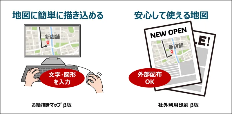
The 'External Printing Beta' feature allows users to easily replicate and print maps for external purposes, accommodating the burgeoning need for business mapping applications. During the feature's availability, premium MapFan members can duplicate and print up to 12 maps without any limitations. Each duplicated or printed map will have a copyright permission number attached, alleviating concerns about intellectual property violations in the creation and distribution of printed materials.
- - Target Audience: MapFan Premium members (annual fee of 3,960 yen)
- - Availability: December 23, 2025 – December 17, 2026
Drawing Map Beta
The 'Drawing Map Beta' feature enables users to annotate maps freely with text, symbols, and arrows. This capability is particularly useful for creating informational maps for roadwork announcements, real estate listings, and promotional flyers. Importantly, any MapFan user can take advantage of this feature.
- - Target Audience: All MapFan users
- - Availability: December 23, 2025 – December 17, 2026
Background of Feature Implementation
The critical issue of aging infrastructure across Japan has raised the need for efficient communication regarding construction activities. In 2024, a significant road collapse due to a burst water pipe in Yashio City, Saitama, escalated the urgency for municipalities to adopt renovation proposals like sewer line duplication and decentralization as recommended by the Ministry of Land, Infrastructure, Transport and Tourism.
In tandem with this growth of necessary roadwork, the need for succinct and targeted information sharing with local residents regarding construction notifications has intensified. Previously, utilizing maps for these business-related applications required cumbersome and costly individual licensing agreements. With the advent of the 'External Printing Beta,' users can now replicate, print, and distribute maps effortlessly and affordably.
Furthermore, by incorporating the 'Drawing Map' feature, users can more efficiently craft informative materials, whether for construction notices or real estate marketing efforts.
Future Prospects
Geotechnologies plans to gauge user feedback regarding these new functionalities through surveys to better understand actual needs. The data collected will inform the consideration of more formal feature additions focused on business map reproduction and printing capabilities.
To learn more about these new features and participate in the survey, visit MapFan Official Site.
About MapFan
Since its launch in 1997, MapFan has become Japan's leading map service, boasting a considerable user base of 3 million free registered members. Employing proprietary digital mapping data, it supports 14 different types of map representations in 13 languages and provides comprehensive information, including VICS data for route optimization, fuel prices, and parking availability. For unlimited access to all features, users can subscribe to the premium service.
Visit MapFan for additional details.
Geotechnologies Company Overview
Founded in 1994, Geotechnologies has consistently delivered digital mapping solutions. Launching MapFan shortly thereafter, the company has pioneered numerous advancements in mapping technologies including the initial i-mode maps and high-precision maps vital for autonomous driving applications. In 2020, Geotechnologies also introduced 'Toriima,' a popular application that connects directly with users, facilitating the collection of real-world insights regarding human movement.
With an emphasis on analyzing vast datasets and geographic information developed over nearly three decades, the company aims to contribute to a more sustainable and comfortable world by providing real-time insights.
Company Details:
- - Headquarters: Bunkyo Green Court Center Office 22F, 2-28-8 Honkomagome, Bunkyo-ku, Tokyo
- - CEO: Yoichiro Yatsukawa
- - Established: May 1, 1994
- - Business Focus: Automotive, Enterprise, Marketing, and Consumer sectors.
- - Corporate Website: Geotechnologies
Topics Consumer Products & Retail)


【About Using Articles】
You can freely use the title and article content by linking to the page where the article is posted.
※ Images cannot be used.
【About Links】
Links are free to use.