Explore the Next-Generation 3D City Model for Osaka-Kansai Expo 2025


Unveiling the 3D City Model for Osaka-Kansai Expo 2025
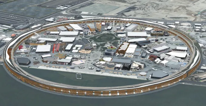
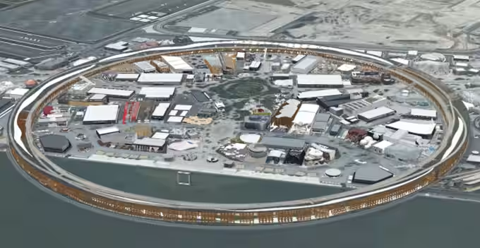
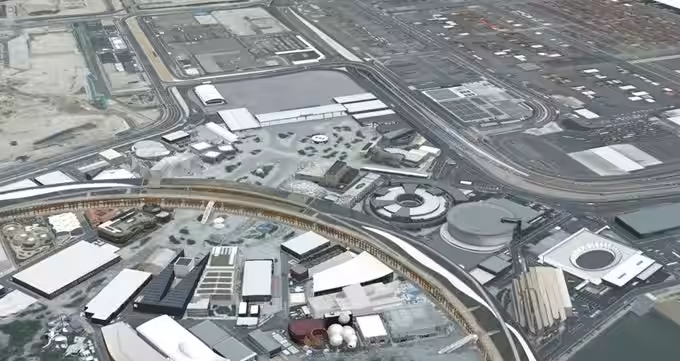
The International Kogyo Corporation, based in Shinjuku, Tokyo, has crafted a detailed 3D city model intended for the Osaka-Kansai Expo 2025, following its selection for a project initiated by the Ministry of Land, Infrastructure, Transport and Tourism. The goal of this significant endeavor is to support the advancement of urban development through digital transformation.
This initiative forms part of “Project PLATEAU,” which was launched in 2020, aiming to create and utilize high-quality 3D urban models across Japan. With this latest model, the focus is on retaining and sharing the architectural splendor of the expo site, which features unique and historically significant structures. By making these models available for use in tourism and events, the project seeks to highlight Japan's pioneering modeling technology on a global stage.
Objectives and Societal Value
The significance of Project PLATEAU lies in its belief that 3D city models provide a new digital infrastructure that can deliver fresh value to society. The creation of the digital archive for the expo venue aims not only to serve as a mere record but to foster the following benefits:
1. International Recognition: Marketing Japan’s sustainable architectural techniques internationally as digital twins that contribute to the nation’s growth.
2. Activation of Local Economy: Encouraging diverse applications such as metaverse tourism and event simulations.
3. Technological Continuity for Future Generations: Supporting young creators in generating new digital content through the use of open data.
Implementation Overview
The project applies advanced techniques developed through Project PLATEAU, combining multi-directional camera shots with 3D laser scanning. This method facilitates the creation of highly detailed 3D city models. The camera initiative, managed by International Kogyo, captures images from five different angles in one flight, enabling the efficient and high-resolution acquisition of complex shapes and textures that traditional aerial photography struggles with.
The 3D laser scanning, a collaborative effort with Kumonos Corporation, emits hundreds of thousands to millions of laser points per second to derive point cloud data of the objects. This process allows for the completion of shadowed and detailed areas of buildings that would otherwise remain hidden in aerial images, resulting in a highly reproducible model data.
Data Release as Open Data
The meticulously prepared data from this project is made accessible through various platforms. Users can interact with and view the actual models using “PLATEAU VIEW,” available through the Ministry of Land, Infrastructure, Transport and Tourism’s website. Among the sources provided are:
- - Ministry of Land, Infrastructure, Transport and Tourism Press Releases
- - PLATEAU View 4.0
- - G-Spatial Information Center 3D city model data
- - G-Spatial Information Center point cloud data
- - Technical verification report on efficient LOD3 model creation methods via multi-directional camera shooting, to be released in March 2025.
With the upcoming Osaka-Kansai Expo 2025, the 3D city model not only transforms how urban environments are viewed but also paves the way for technological advancements and shared cultural heritage for future generations.
Topics Other)


【About Using Articles】
You can freely use the title and article content by linking to the page where the article is posted.
※ Images cannot be used.
【About Links】
Links are free to use.