FLIGHTS DOCS Launches Handheld Scanner Integration for Efficiency


FLIGHTS DOCS Introduces New Handheld Laser Scanner Integration
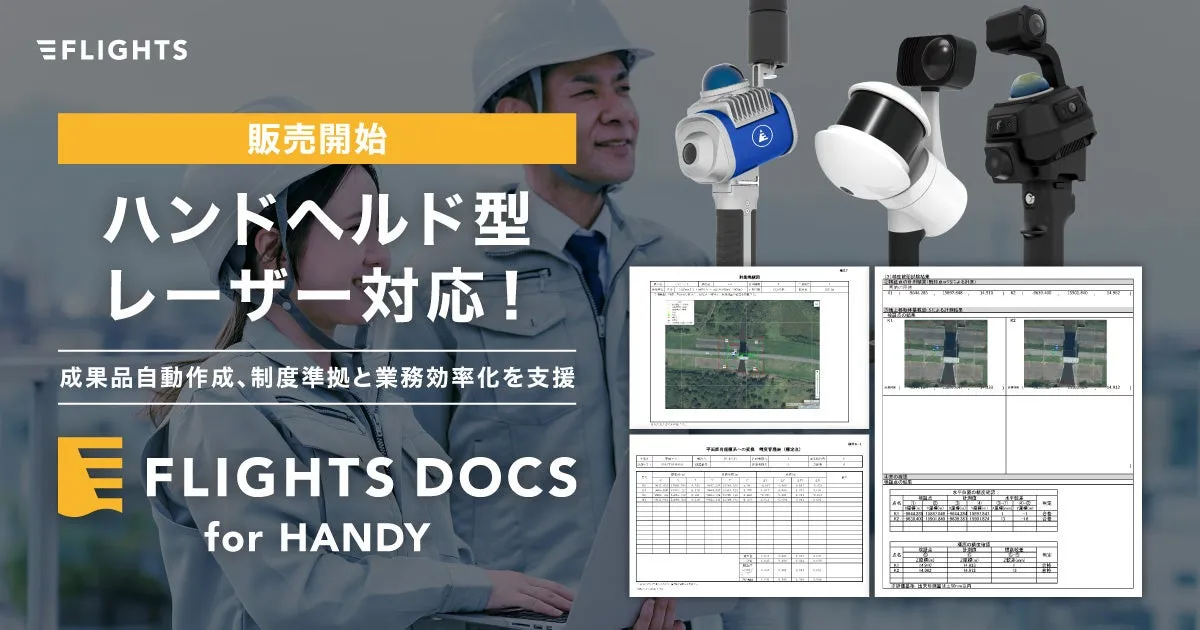
In a significant development for the surveying industry, FLIGHTS, a Tokyo-based technology startup, has announced that its web service, FLIGHTS DOCS, is now compatible with multiple handheld laser scanners, including the FLIGHTS SCAN HANDY. This new offering, dubbed "FLIGHTS DOCS for HANDY," aims to streamline the data management process in drone laser surveying, ensuring compliance with the latest regulations.
Overview of FLIGHTS DOCS for HANDY
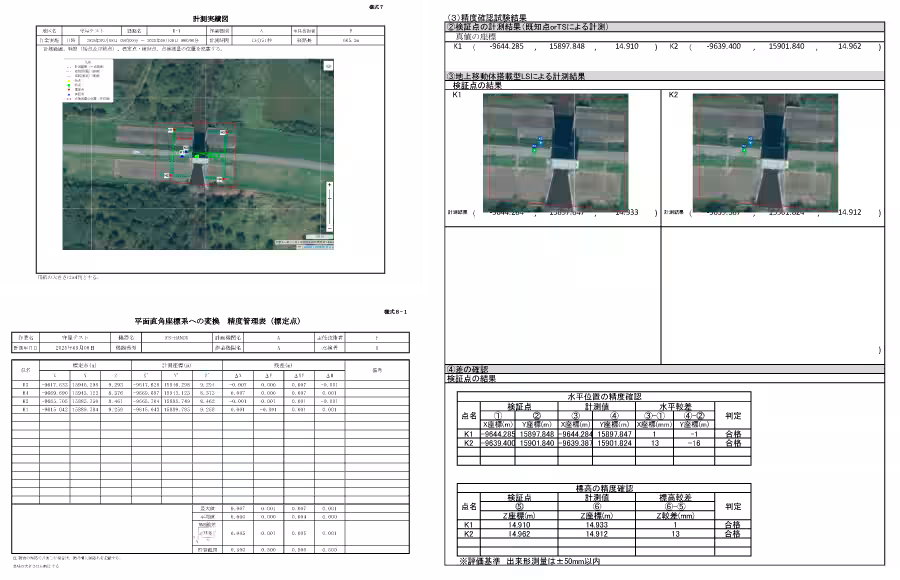
FLIGHTS DOCS for HANDY is designed specifically to aid in the creation of survey deliverables for public measurements and i-Construction by efficiently generating required reports. Users simply input measurement route files and data for reference and verification points, allowing the system to automatically generate the necessary documentation. This automation alleviates tedious manual processes, significantly improving operational efficiency.
Key Features
- - Automatic Creation: Users can create deliverables by merely entering their measurement paths and reference point data.
- - Regulatory Compliance: The service adheres to the most recent guidelines from the Ministry of Land, Infrastructure, Transport and Tourism and the Geospatial Information Authority of Japan.
- - Efficiency Increase: By preventing rework in document preparation, the service helps reduce labor costs.
- - Quality Assurance: FLIGHTS supports projects from the field to delivery, ensuring consistent quality.
Main Functionalities
FLIGHTS DOCS for HANDY includes a suite of 12 standard report formats for automated generation and two types of accuracy verification reports. However, it is important to note that compatibility depends on using versions of LiDAR360MLS v8 or higher, and some formats may not be replicable with other software.
Compatible Devices
This service is recommended for use with various handheld scanners:
- - FLIGHTS SCAN HANDY
- - Manifold Tech MindPalace Pocket2
- - GreenValley International LiGrip Series
Customers can purchase compatible devices through FLIGHTS or authorized resellers.
The Allure of FLIGHTS DOCS for HANDY
1. Unified Workflow: Users can consolidate data from both handheld and drone scanners, whether operating independently or in conjunction. The system supports all data combinations seamlessly.
2. Multiple Route Additions: For sites requiring multiple measurement paths, users can quickly add routes with a single click.
3. Web-Based Convenience: As a web service, accessibility is guaranteed from anywhere at any time, fostering increased efficiency. Subscription plans are available, allowing easy initiation of services; however, a minimum commitment of six months is required.
Development Background
The construction industry is currently grappling with labor shortages and the pressing need for enhanced productivity. Digital transformation (DX) has become crucial in addressing these challenges. Drone surveying, with its ability to cover extensive areas quickly, is being adopted widely across various construction sites, making FLIGHTS DOCS an efficient solution for laser surveying.
The shift to include handheld laser scanners caters to areas where drones may face limitations, such as indoor configurations, intricate structures, and densely vegetated areas. This adaptation significantly improves service delivery speed and accuracy.
FLIGHTS DOCS is now equipped to effectively manage point cloud data obtained through handheld devices, ensuring that measuring tasks in construction can proceed smoothly and efficiently, further promoting DX in the industry.
Conclusion
FLIGHTS, with a focus on digitizing and optimizing measurement processes within the construction sector, demonstrates a growing dedication to incorporating advanced technologies. Their solutions, like the FLIGHTS DOCS for HANDY, provide vital support in raising productivity and efficiency at construction sites.
For more information about this latest offering and other features, please visit FLIGHTS Official Site. For inquiries related to the products and services mentioned, please reach out to the FLIGHTS LiDAR Division at [email protected].


Topics Business Technology)
【About Using Articles】
You can freely use the title and article content by linking to the page where the article is posted.
※ Images cannot be used.
【About Links】
Links are free to use.