
Map of Accident-Prone Intersections Released Nationwide: Ikebukuro's Intersection Tops the List


Map of Nationwide Accident-Prone Intersections
The Japan Insurance Association, led by Chairman Shinichiro Funabiki, has released the 2025 edition of the "Nationwide Accident-Prone Intersection Map". This initiative aims to reduce and prevent traffic accidents, which is particularly urgent as over half of personal injury accidents in the country occur at or near intersections. The map presents a ranked list of intersections with high accident occurrence, developed in cooperation with local prefectural police.
This informative map has gained significant media attention, frequently being covered in newspapers and on television. Released every December, it coincides with the time of year when traffic accidents peak, according to the Japan Insurance Association's research which draws from police statistics from 2022 to 2024. To enhance public safety and awareness, individuals and families are encouraged to familiarize themselves with nearby accident-prone intersections, ensuring safer driving practices.
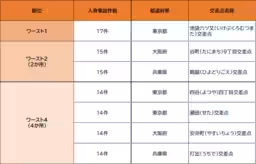
Ikebukuro's Intersection Holds the Title
For two years running, the intersection known as "Ikebukuro Mutsubata Intersection" has taken the unfortunate title of the most accident-prone location in Japan. This primary designation underscores the pressing need for increased transportation safety measures in this area. Additionally, various improved examples resulting from effective traffic safety campaigns will be showcased on the map.
You can consult other accident-prone intersections through the "Nationwide Accident-Prone Intersection Map" website, which serves as a valuable resource for understanding traffic hazards. The map can be utilized in multiple scenarios, such as:
- - Safety inspections on school routes
- - Traffic safety training materials within corporate settings
- - Reference material for media reports and research
The map helps not just everyday citizens, but also municipalities, educational institutions, businesses, and media entities to visualize accident risks associated with traffic. Through this novel resource, the goal is to raise awareness among both drivers and pedestrians regarding their responsibilities on the road, promoting overall traffic safety.
Take Action for Safety
As we approach December, it is vital for drivers and pedestrians alike to take heed of this critical information. The map provides an essential perspective on the data surrounding traffic accidents, compelling all stakeholders to consider ways in which safety can be improved in these high-risk areas.
Contact Information
For more details, the Japan Insurance Association’s Public Relations Office in the Management Planning Department can be reached at 03-3255-1213. They are open to inquiries and discussions regarding the findings and applications of the accident-prone intersection map.
By leveraging the insights from the map, all community members can contribute to the discourse around traffic safety. The hope is that through heightened awareness and educated driving practices, we can all work toward reducing the number of traffic accidents in Japan.
Topics Policy & Public Interest)
【About Using Articles】
You can freely use the title and article content by linking to the page where the article is posted.
※ Images cannot be used.
【About Links】
Links are free to use.