ESRI Japan and NTT Infranet Launch Precise 3D Spatial Data on ArcGIS Online


High-Precision 3D Spatial Data Unveiled on ArcGIS Online
In an exciting development for Geographic Information Systems (GIS), ESRI Japan and NTT Infranet have jointly announced the availability of high-precision 3D spatial data on the renowned ArcGIS Online platform. This collaboration strengthens their sales partnership and expands the offerings available through ESRI Japan's GIS data catalog site, known as the GIS Data Store.
ESRI Japan, which stands as the leading domestic provider of GIS software, aims to enhance accessibility to various data contents that can be utilized within its ArcGIS software. Visitors to the GIS Data Store can explore a diverse range of data categories and easily access product details such as features and pricing through intuitive links. With the addition of NTT Infranet’s high-precision 3D spatial information, the platform now provides even more value to its users.
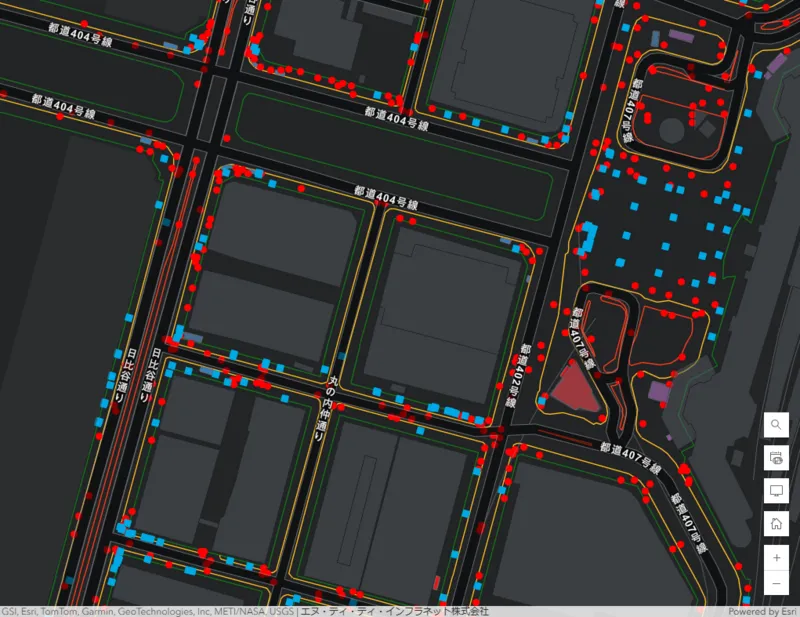
The newly launched high-precision 3D spatial data is built upon a high-resolution aerial imagery base (GSD5cm) and utilizes Mobile Mapping System (MMS) data. This advanced three-dimensional database encompasses critical information including road boundaries (such as sidewalks and medians), entrances and exits above and below ground, as well as the precise locations of manholes. This data is not only significant for visualization but can also be processed within the ArcGIS Pro software for more complex applications like Building Information Modeling (BIM) alignment and civil engineering designs using Autodesk Civil 3D software. The synchronization of real-world coordinates through ArcGIS Online opens up vast possibilities for data utilization beyond mere mapping.
Visualizing the Data

_Visual example of high-precision 3D spatial information displayed on ArcGIS Online._
The partnership between ESRI Japan and NTT Infranet aligns both companies' strengths, reinforcing their commitment to deliver comprehensive software, services, and systems that cater to all aspects of GIS. They aim to not only support the growth of the GIS community but also contribute meaningfully to society at large. By fusing cutting-edge technology with user-friendly platforms, this collaboration is set to redefine how spatial data is utilized across various sectors.
This initiative underscores the market potential highlighted in the Deloitte Tohmatsu Research Institute's Business Analytics Market Outlook 2022, which indicates that GIS technology is evolving rapidly and becoming integral across multiple industries. Such advancements promise to benefit urban planning, environmental impacts assessments, and infrastructure developments immensely.
Company Background
ESRI Japan, Inc.
- - Headquarters: 2-7-1 Hirakawa-cho, Chiyoda-ku, Tokyo, 102-0093, Japan
- - CEO: Hitoshi Yamaguchi
- - Established: April 1, 2002
- - Business Scope: Sales of GIS software and provision of related services including support, training, and consulting.
- - Website: www.esrij.com
This launch marks not just a milestone for the companies involved but also a significant step towards a more data-driven approach to GIS, promising enhanced capabilities and innovative use cases for users across the globe.
Topics Consumer Technology)


【About Using Articles】
You can freely use the title and article content by linking to the page where the article is posted.
※ Images cannot be used.
【About Links】
Links are free to use.