Geotechnology and SpaceShift Enhance Mapping Efficiency with AI and SAR Data


Transforming Mapping with Cutting-Edge Technology
In an era where accurate mapping is crucial for various industries, Geotechnology Inc. (based in Bunkyo, Tokyo) and SpaceShift Inc. (headquartered in Chiyoda, Tokyo) are making significant strides in advancing mapping efficiency through their innovative use of AI and SAR (Synthetic Aperture Radar) satellite data. This collaboration has resulted in a remarkable increase in the building update rate for Geotechnology, achieving a rate 1.8 times higher than previous standards. This breakthrough underscores the potential of merging satellite technology with artificial intelligence to streamline geospatial data processes.
Challenges Faced in Mapping Operations
Geotechnology's mapping operations span the entirety of Japan, necessitating continuous updates of vast areas using various data sources, including satellite imagery. However, much of the obtained data contains areas without significant changes, limiting its direct applicability to mapping activities. Consequently, effectively identifying areas needing updates has become a pressing challenge.
The Journey Toward Collaboration
SpaceShift, known for its development of building change detection algorithms using AI, began its partnership with Geotechnology in 2022. Initial efforts focused on validating technology through targeted comparisons of change points in select regions. Through ongoing discussions, both companies explored the potential for improvement in mapping processes, culminating in a large-scale proof-of-concept (PoC) experiment covering a quarter of Japan in September 2023. The successful results of this PoC prompted Geotechnology to adopt SpaceShift's satellite data-driven building change detection solution officially, marking a significant advancement in their mapping capabilities starting from fiscal year 2024.
Effective Solutions for Enhanced Mapping
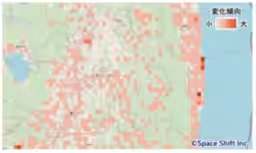
Employing SAR satellite data, which is not affected by weather conditions, SpaceShift's proprietary AI analyzes structural changes, providing vital information on new constructions and demolitions. As a result, Geotechnology is now able to pinpoint areas undergoing substantial changes across Japan with precision, streamlining satellite image procurement and optimizing their mapping workflow.
Benefits of the New Solution
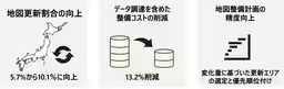
1. Enhanced Building Update Rate: The solution has increased the mapping update rate from an average of 5.7% pre-implementation to approximately 10.1% post-implementation.
2. Cost Reduction: By focusing on areas with frequent changes, the solution enables a cost reduction of 13.2% in mapping operations, significantly improving cost efficiency.
3. Objective Improvement in Mapping Accuracy: Utilizing building change detection as an objective criterion allows Geotechnology to prioritize areas for updates more effectively, facilitating a more strategic approach to nationwide mapping efforts.
Insights from Leaders
Ikue Yanba, Manager of Geotechnology's Map Development, stated, “The integration of SpaceShift's SAR satellite data analysis technology has allowed us to make precise selections for sourcing materials, leading to enhanced productivity through efficient change reflection.” She emphasized the importance of understanding their mapping workflow, which contributed to a seamless implementation process.
Kazushi Motomura, the Chief Technology Officer at SpaceShift, expressed excitement about this collaboration, remarking, “The introduction of our AI-powered SAR satellite data solution nationwide is a definitive example of utilizing the vastness of satellite data, demonstrating the potential of integrated technology in managing building changes.”
Future Prospects
Geotechnology's involvement in SpaceShift's SateBiz co-creation program illustrates their dedication to exploring new possibilities for satellite data in mapping operations. By continuing their partnership, both companies aim to push the boundaries of traditional mapping methodologies and ensure a sustainable, technologically advanced future in geospatial data management.
About Geotechnology
Founded in 1994, Geotechnology has been a leader in digital mapping solutions. Over the years, they have developed numerous innovations, including Japan's first i-mode maps and advanced navigation tools for autonomous driving applications. With their release of the popular sweepstakes app “Torima” in 2020, the company has also begun gaining invaluable insights into real-world mobility and awareness through user interactions.
For more information, visit their website.
About SpaceShift
Established in December 2009, SpaceShift specializes in software development that utilizes data from earth observation satellites and AI to monitor various changes on Earth, directly applying this technology to sectors such as infrastructure management, disaster prevention, and environmental conservation. Their slogan, “Sense the Unseen from Orbit,” presents their vision of creating a sustainable society through the effective use of satellite data.
For further details, visit their website.
Topics General Business)
【About Using Articles】
You can freely use the title and article content by linking to the page where the article is posted.
※ Images cannot be used.
【About Links】
Links are free to use.