Shizuoka City's Innovative Flood Simulation System: A National First for Real-Time Alerts


Shizuoka City Unveils Advanced Flood Simulation System
In a bid to safeguard its citizens against flooding disasters, Shizuoka City has launched the innovative "Tamagawa Flood Information System," which marks a first for the nation by providing real-time flood simulation and information directly to the public. Developed with technical support from the Construction Technology Research Institute, this state-of-the-art system integrates hydrological data to deliver precise flood level assessments based on current weather conditions. The official deployment is set to commence in May 2025, yet the groundwork is already in motion.
Features of the Tamagawa Flood Information System
The newly established system utilizes an advanced numerical simulation model that calculates the current extent of flooding based on real-time rainfall measurements and river water levels. It's designed to be user-friendly, delivering immediate alerts and updates to residents, which is crucial for timely evacuation and disaster preparedness. This effort showcases a commitment to utilizing technology for public safety in a region vulnerable to flooding hazards.
Cutting-edge Integration for Precise Analysis
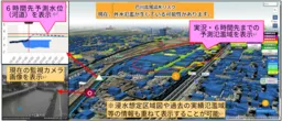
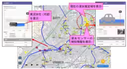
One of the system's most prominent attributes is its comprehensive analytical approach, which seamlessly evaluates rainfall runoff from river basins, river and canal flow, as well as urban flooding scenarios all together. By combining various models— including runoff models, one-dimensional unsteady flow models of rivers and canals, sewerage models, and two-dimensional flood inundation models— the system can accurately predict current flooding conditions. This high-precision flood assessment enables real-time updates every 10 minutes, offering residents consistent information to aid in their safety decisions. Additionally, sensors installed at 117 locations throughout the city will enhance the system's accuracy by integrating live detection data.
A Trailblazer for Local Governments
This initiative stands out as the first of its kind in Japan, where a local government takes the proactive step to publicly announce current flood extent estimates through simulated data. Notably, the system is not only responsive to immediate weather conditions but also forecasts potential flooding scenarios up to six hours in advance based on predicted rainfall data. Such capabilities are invaluable for issuing early evacuation alerts and making timely calls for road closures during severe weather events.
Powered by RisKma: Enhancing Rapid Information Distribution
The Tamagawa Flood Information System leverages the platform developed by the Construction Technology Research Institute, known as "RisKma". This flood risk mapping system has been refined over the years to ensure swift visualization and dissemination of essential information, including 3D graphical representations that enhance understanding of flood risks. Future expansions of the platform will include simulations that gauge the effectiveness of flood management strategies, further strengthening the disaster resilience capabilities of local governments.
As Shizuoka City gears up to fully implement this pioneering system, it sets a compelling precedent for other municipalities across Japan to follow in using technology to foster public safety and resilience against natural disasters. The collaboration between local government and research institutions exemplifies how innovative solutions can play a critical role in addressing the challenges posed by climate change and environmental uncertainties.

Topics Policy & Public Interest)
【About Using Articles】
You can freely use the title and article content by linking to the page where the article is posted.
※ Images cannot be used.
【About Links】
Links are free to use.