Innovative Off-Grid Drone Ports Revolutionize Slope Monitoring in Japan


Off-Grid Drone Ports: A Game Changer for Slope Monitoring
In a significant advancement in construction safety, SORABOT and Yachiyo Engineering are conducting groundbreaking tests utilizing off-grid drone ports to monitor slopes autonomously. This trial is being implemented in the landslide disaster zone of Noto Peninsula, Wajima City, under the jurisdiction of the Ministry of Land, Infrastructure, Transport and Tourism's Hokuriku Regional Development Bureau. From August 21 to October 3, 2025, these innovative drone ports will enable remote operation and surveillance of hillside conditions.
Background of the Experiment
The construction industry in Japan faces pressing issues such as a declining workforce and the need for work style reforms. There’s an urgent demand for improved productivity through ICT technologies, especially in dangerous areas prone to landslides and rockfalls. Traditionally, monitoring terrain changes involved manual inspections or relying on visual comparisons of drone-captured images, a method that proved time-consuming and labor-intensive. Such techniques made it challenging to quantitatively measure shifts in rock movement or soil displacement. The introduction of off-grid drone ports—which can operate independently of electrical grids—marks a revolutionary step forward in ensuring safety while increasing efficiency in construction management.
Details of the Demonstration Experiment
This innovative experiment aims to establish a routine of automated drone flights from a permanently installed drone port. Every day, drones will take off at scheduled times, collecting data that is then automatically compared and analyzed by AI in the cloud. This allows the team to acquire accurate assessments of slope conditions from remote locations.
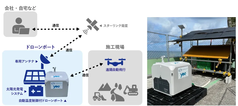
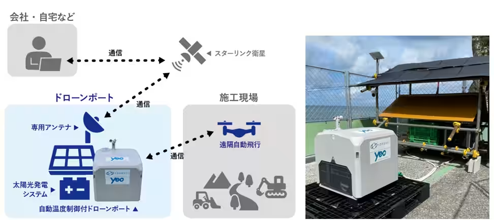
Versatile Off-Grid Drone Port Features
The off-grid drone ports provide a reliable solution even in locations devoid of conventional power sources, utilizing satellite communication to secure connectivity. By integrating solar panels with portable batteries, these ports can conduct drone operations autonomously. To ensure these sensitive drones operate smoothly, they are equipped with systems for optimizing internal temperatures and surveillance cameras to prevent theft. This setup proves invaluable for monitoring risks associated with landslides, volcanic eruptions, and tsunami alerts—tasks that would otherwise require significant manpower.
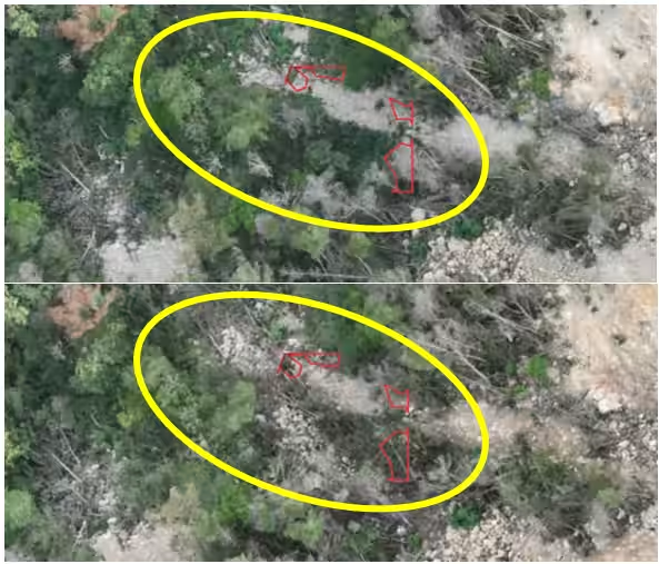
Advanced 3D Point Cloud Data for Terrain Change Detection
One of the standout features of this experiment involves 3D point cloud data analysis, going beyond traditional flat images. This technology enables more refined comparisons, allowing for the detection of subtle terrain changes and the quantification of displaced soil volumes, which are typically hard to spot with the naked eye. Furthermore, expert analysis by geological and geotechnical engineers leads to precise risk assessments that can be employed in real-world risk management.
Integrating Into Daily Operations
The automation process begins each day at 6:30 AM when drones take to the skies. Upon their return, orthophotos, point clouds, and 3D mesh models are generated instantly. The AI then compares the orthophotos, analyzing data against the previous day’s imagery. Results are available by 8 AM for the project team to review, facilitating informed planning and risk evaluation for the day’s operations. In scenarios where significant changes occur, such as during heavy rainfall, the team can manually conduct point cloud difference analysis for a more detailed understanding of terrain alterations. This data-driven approach is expected to enhance overall safety significantly.
Outcomes and Benefits
The experimental phase has shown great promise in achieving objective risk assessments based on consolidated data. This supports the creation and execution of actionable safety protocols, dramatically increasing safety management levels on site.
Established Daily Safety Monitoring Processes
- - Automated daily analysis allows rapid sharing of terrain differences among stakeholders, effectively highlighting risks to be managed each day.
- - The efficiency of operations has improved significantly by minimizing the need for on-site inspections, thus saving valuable time.
- - When real landslide events were detected, precise 3D data enabled swift reactions, leading to the introduction of tangible safety measures, such as the deployment of large sandbags.
Future Challenges
Looking ahead, the objective is to fully automate the established workflow. This would include real-time difference analysis of point cloud data as soon as it’s collected by drones. Implementing such capabilities could dramatically enhance disaster preparedness, allowing for quicker, more accurate readings of potential hazards. Improved evaluation will thus fortify site safety and support quicker risk mitigation strategies, aiding in both routine supervision and construction progress management.
Company Backgrounds
SORABOT LLC
As a comprehensive partner for implementing industrial drones, SORABOT offers a wide range of services including sales, design, operation support, and contract services, with a strong focus on drone ports. SORABOT excels in supporting monitoring and risk management efforts across various sectors including railway, energy, construction, and disaster prevention.
Location: Kanagawa, Yokohama City, Tsuzuki-ku 5-20-9-503
CEO: Hideki Okumura
Incorporated: September 20, 2022
Website: SORABOT
Yachiyo Engineering Co., Ltd.
As a leading comprehensive construction consulting firm in Japan, Yachiyo Engineering works extensively with government agencies, providing technical consulting services for social infrastructure and environmental protection for over 60 years. Recently, they have expanded their services into the private sector, applying their established technical expertise to broader business challenges.
Location: Tokyo, Taito-ku, Asakusabashi 5-20-8 CS Tower
President: Tsutomu Takahashi
Incorporated: January 29, 1963
Website: Yachiyo Engineering
Topics Consumer Technology)
【About Using Articles】
You can freely use the title and article content by linking to the page where the article is posted.
※ Images cannot be used.
【About Links】
Links are free to use.