AI-Powered River Water Level Prediction Model Achieves 89% Accuracy in Flood Risk Management


AI-Powered River Water Level Prediction Model
Recent advancements in AI technology are making significant strides in flood management, particularly with the development of a river water level prediction model by Vector Design based in Shibuya, Tokyo, in collaboration with Number Holdings from Takaoka, Toyama. This innovative model can predict substantial water level increases in rivers with an impressive accuracy of 89% within a critical 30-minute timeframe.
As climate change escalates extreme weather events, the risk of flooding is no longer confined to large rivers; urban streams and smaller waterways are also becoming increasingly vulnerable. The necessity for effective flood prevention measures is paramount, especially as the impact of flooding can have severe consequences on lives and property.
The prediction model leverages Microsoft Research's machine learning algorithm, LightGBM (LGBM). By using data from existing monitoring stations, the model has been tailored to predict water level fluctuations for specific locations. Such preciseness enables local governments to take timely actions in their flood response efforts.
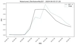
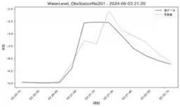
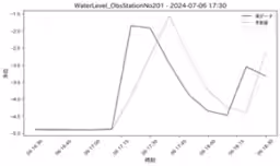
During the initial experiments, the AI model was tested with data from rivers within the Tokyo area, successfully predicting water level surges that could occur 20 to 30 minutes later with remarkable accuracy of 89% (R2).
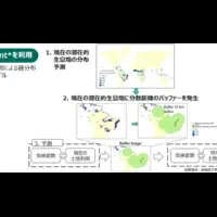
The team plans to enhance prediction capabilities by utilizing data from the Ministry of Land, Infrastructure, Transport and Tourism's XRAIN rain radar and Japan Meteorological Agency's Nowcast systems. This will enable forecasts to be made more than one hour in advance, potentially saving countless lives and minimizing damage.
Despite the current focus on Tokyo, the versatility of the model allows it to be applied nationwide. By utilizing historical data held by local governments, predictive models can be constructed for river monitoring points across the country. Furthermore, the model will include an automatic system that compares the predicted values with actual measurements from established monitoring stations to consistently improve accuracy.
Looking ahead, the second phase of experimentation is scheduled to commence in September 2025. This phase will focus on four main themes:
1. Application and verification of the model across multiple rivers in Tokyo to improve predictive accuracy.
2. Utilization of deep learning models, specifically Time Series Transformers, to further enhance prediction precision.
3. Identification of key measurement points with significant water level fluctuations using the 250m mesh coordinates from the Ministry's XRAIN system.
4. Testing a system (STIV) that measures river flow speed through surveillance camera footage.
This innovative service, based on the results of the second phase, is set to be launched in Spring 2026 as part of Vector Design's cloud disaster prevention system, Qumowill PRO, aimed at supporting flood response organizations.
Upcoming releases will further include support for the 250m mesh features and more cost-effective solutions, all poised to revolutionize flood risk management as we know it.

Topics Environment)


【About Using Articles】
You can freely use the title and article content by linking to the page where the article is posted.
※ Images cannot be used.
【About Links】
Links are free to use.