



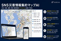
Launch of AI-Powered Disaster Information Map Following Kumamoto Earthquake
AI-Powered Disaster Information Map Launched Amid Kumamoto Earthquake
On July 28, 2026, a significant earthquake struck the Kumamoto region, registering a magnitude of 7.1 and reaching a maximum intensity of 7 on the Japanese seismic scale. In response to the urgent need for accurate information, Solafune, a Tokyo-based company, swiftly launched an innovative tool known as the "AI-Powered Disaster Information Map."
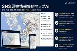
This map aims to consolidate information from various sources, including social media, news outlets, and governmental agencies, into one accessible platform. It enables users to visualize the impact of the earthquake in real time and is available for free to anyone with internet access.
Key Features of the Disaster Information Map
The AI-Powered Disaster Information Map offers a wide range of functionalities:
- - Real-Time Earthquake Data: Users can view the epicenter, magnitude, and maximum seismic intensity as reported by the Japan Meteorological Agency on the map.
- - Evacuation Centers: The map highlights evacuation centers in Kumamoto City and surrounding municipalities, providing crucial data on the number of evacuated households and individuals, as well as capacity information for other local shelters.
- - Emergency Refuge Locations: It lists 3,028 designated emergency refuge areas and shelters throughout Kumamoto Prefecture.
- - Heat Index Monitoring: Users can track “caution” level or higher heat index values at various monitoring locations as published by the Ministry of the Environment.
- - Analysis of Social Media Posts: The tool utilizes AI technology to analyze and categorize public posts from platforms like X and Instagram, allowing users to see the damage caused by liquefaction, flooding, fires, and more, pinpointed on the map.
- - Data Filtering and Sorting: Users can filter data by municipality, information type, or keywords and can sort the information by urgency or chronologically, based on when the disaster occurred.
- - Downloadable Data: For media outlets and municipalities, data can be downloaded in CSV or GeoJSON formats for further analysis or mapping purposes.
- - Various Background Options: Users can choose between light-colored maps, standard maps, or aerial photos taken before the disaster for better contextual understanding.
It is important to note that media articles can be viewed on the map, displaying only the headline, publication name, date, and a link to the original article, while ensuring that full contents like photos or videos are not included to maintain copyright standards. Furthermore, Solafune commits to regularly updating the displayed information.
Context of the Launch
After a disaster, the dissemination of information is often chaotic, making it difficult for residents to assess the situation in their local areas. Recognizing this challenge, Solafune has been working on satellite data and the analysis of social media during disaster situations. The company prioritized the rapid rollout of this platform to assist the community in need during this critical time. As the situation evolves, they are committed to continuously improving the map’s functionalities and updating the information provided.
User Advisory
While the map gathers information automatically from publicly available sources, users are advised that the accuracy and comprehensiveness of the information cannot be guaranteed. It is crucial that individuals adhere to announcements made by official sources such as the Japan Meteorological Agency and local governments when making evacuation decisions. Any inquiries or requests regarding the information included can be directed to Solafune via their contact email at [email protected].
About Solafune
Solafune, located at Marunouchi Building, 2-4-1 Marunouchi, Chiyoda-ku, Tokyo, Japan, is dedicated to leveraging technology for societal benefit, particularly in crisis situations. More information about the company and its initiatives can be found on their official website here.
Topics Other)
【About Using Articles】
You can freely use the title and article content by linking to the page where the article is posted.
※ Images cannot be used.
【About Links】
Links are free to use.