
FLIGHTS Launches New Web Service 'Rakusoku Geo' to Streamline Volume Management


Introducing 'Rakusoku Geo'
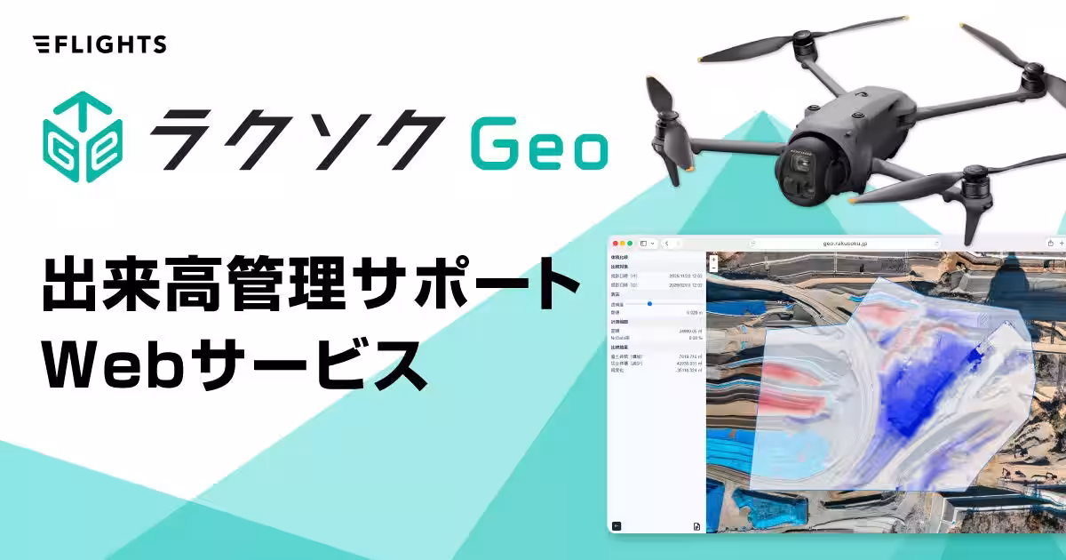
FLIGHTS Co., Ltd. (CEO: Shuhei Togeshita) has officially launched its volume management support web service, 'Rakusoku Geo', which will be available for registration starting on April 2, 2026. This cutting-edge service aims to resolve significant challenges in volume management by offering an intuitive, fast, and affordable solution that is easy for anyone to use.
Addressing Industry Challenges
The construction industry is currently facing an aging workforce and a severe shortage of skilled labor, emphasizing the urgent need for sustainable infrastructure development. Recognizing this trend, FLIGHTS has focused on creating and providing LiDAR measurement tools and software for the construction and surveying sectors. Through this journey, they have often heard about the critical lack of effective options in volume management, which needed to be addressed.
Existing methods have several persistent issues, including:
- - Manual and Simplistic Calculations: Time-consuming and low reproducibility due to reliance on specific individuals.
- - Specialized Software: High operational difficulty leading to inconsistent output quality and high implementation costs.
- - Cloud Services: Long processing times and overly complex functionalities, resulting in high monthly fees.
To tackle these challenges, FLIGHTS developed 'Rakusoku Geo' with the concept of enabling anyone to perform measurements quickly and effortlessly. The service combines high-speed processing and an intuitive user interface, all at a competitive price, thereby minimizing initial implementation costs.
Service Overview and Key Features
1. Comprehensive Support for Volume Management
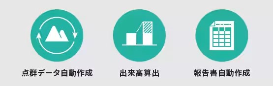
Rakusoku Geo includes three basic features that ensure efficient management:
- - High-Precision Point Cloud Generation: Simply upload drone survey images to create precise point cloud data.
- - Volume Calculation: Determine earthworks volume by comparing two points in time.
- - Automatic Report Generation: Effortlessly produce reports to submit to clients with one click.
2. User-Friendly Interface and Simple Workflow
The platform features an intuitive design that allows users to drag and drop their image files for upload and automatically generate reports with just a single click. The process is divided into three simple steps:
1. Drag and drop your drone-captured photos into the system.
2. Specify the area for which you want to calculate volumes from the automatically generated data.
3. Generate the required volume report in the desired format at the click of a button.
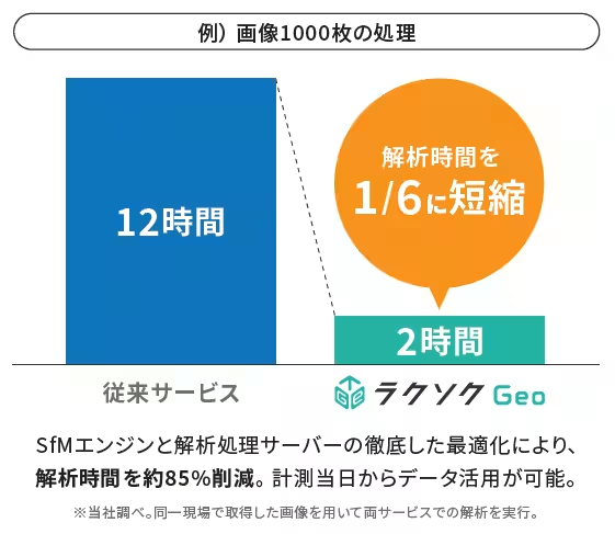
3. Exceptional Image Processing Speed
By optimizing the SfM engine and processing servers, Rakusoku Geo can reduce analysis time by approximately 85%. For instance, processing 1,000 images that would typically take around 12 hours with conventional methods can be completed in just 2 hours with this new service. This allows users to access analyzed data on the same day the measurements are taken.
4. Flexible Service Plans
Rakusoku Geo offers two main plans: the 'Starter Plan' and the 'Basic Plan,' both designed for a contract duration of 12 months and accommodating up to 10 registered users. Customers can choose the best plan based on the volume of processed images and storage requirements. Additionally, a 'Custom Plan' is available for those needing tailored conditions based on specific operational needs.
Special Launch Campaign
In celebration of the official launch, FLIGHTS is offering a special campaign that allows potential users to minimize implementation costs and try out Rakusoku Geo at an attractive rate. For more details and inquiries about the service plans or to request a demonstration, please visit the official website.
Sales Information
Registration Start Date: April 2, 2026
Website: Rakusoku Geo
FLIGHTS Co., Ltd. is a tech startup focused on enhancing measurement operations in the construction industry through drone technology and digital solutions. With experienced team members who understand the various aspects of surveying and relevant regulations, FLIGHTS continues to innovate with products like 'FLIGHTS SCAN' for LiDAR surveying and 'FLIGHTS CONTROL' for bridge inspections. For further inquiries related to the products and services mentioned in this press release, please contact FLIGHTS' LiDAR Division at [email protected].

Topics Consumer Technology)
【About Using Articles】
You can freely use the title and article content by linking to the page where the article is posted.
※ Images cannot be used.
【About Links】
Links are free to use.