


Space Shift and GeoTechnologies Revolutionize Mapping with AI and SAR Data
Introduction
In a groundbreaking collaboration, Space Shift Inc. and GeoTechnologies Inc. have harnessed the power of Synthetic Aperture Radar (SAR) satellite data alongside advanced AI to optimize building change extraction processes. This innovative solution has enabled GeoTechnologies to enhance its mapping operations significantly, with building update rates improving by 1.8 times compared to previous methods.
Background of Mapping Challenges
GeoTechnologies, which offers extensive mapping services across Japan, faces a significant challenge in continuously updating maps for a vast region. To carry out these updates efficiently, they rely on satellite images and large datasets to track changes in buildings and roads. However, many of the data points they receive may include areas with no changes at all, rendering them relatively unhelpful for direct utilization in mapping operations. To address this, their main challenge was determining areas of change effectively and selecting relevant data to improve efficiency.
History of Collaboration and Overview of Solution
Beginning in 2022, Space Shift commenced a partnership with GeoTechnologies to develop algorithms for building change detection via AI. This collaboration began with technical trials focusing on specific regions, aiming to explore possibilities for utilizing these advancements in GeoTechnologies' mapping processes.
In September 2023, a large-scale proof of concept (PoC) was conducted covering a quarter of Japan. Following the success of this test, GeoTechnologies officially decided to implement Space Shift’s building change extraction solution, utilizing SAR satellite data starting in 2024.
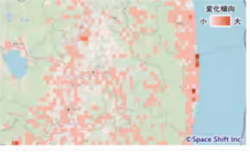
The solution employs SAR satellite data—insensitive to weather conditions—and analyzes it with Space Shift's proprietary AI technology to provide insights on construction activities, such as new buildings or demolitions. Thanks to this capability, GeoTechnologies can accurately and consistently identify areas with significant building changes throughout Japan, allowing for optimized resource management in satellite image acquisition and research.
Benefits of Implementing the Solution
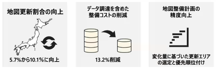
The integration of this solution has resulted in substantial benefits for GeoTechnologies, including:
1. Increase in Building Update Rates:
The proportion of updates concerning buildings has improved significantly from about 5.7% before implementation to an impressive 10.1% afterward due to the enhanced data acquisition focused on areas with significant changes.
2. Reduction of Mapping Costs by 13.2%:
By efficiently procuring satellite images targeted at change-prone areas, GeoTechnologies achieved a 13.2% reduction in overall mapping costs, streamlining the entire process.
3. Improved Precision in Mapping Plans:
The ability to select update targets based on objective indicators of building change has allowed for prioritization in nationwide map updating, enhancing the effectiveness of resource allocation.
Expert Insights
Ikue Yanba, the manager of Map Development at GeoTechnologies, commented on the partnership, stating, "Integrating Space Shift’s SAR satellite data analysis technology has enabled more accurate selection of areas for data acquisition, leading to increased productivity through efficient information updating. Their engagement with our mapping teams helped facilitate a smooth introduction of this technology. We look forward to further collaborations for even better solutions."
Kazushi Motomura, Chief Technology Officer of Space Shift, expressed his thoughts, noting, "This demonstration marks a significant leap in applying SAR satellite data coupled with our AI for nationwide monitoring of building changes. I’m excited about this ideal case utilizing the expansive reach of satellite data and Stable SAR technology. Collaboration and discussions prior to the tech demonstration were invaluable, leading us to this full-scale implementation."
Future Outlook
GeoTechnologies aims to deepen its partnership with Space Shift as part of the SateBiz joint business program to explore new possibilities in satellite data for mapping operations. Their collaborative efforts will continue to focus on improving mapping efficiency and quality metrics in the future.
About Space Shift
Founded in December 2009, Space Shift Inc. operates under the motto "Sense the Unseen from Orbit," developing software that analyzes data obtained from Earth observation satellites using AI. The company aims to leverage satellite data across various fields including infrastructure management, disaster risk reduction, agricultural monitoring, and environmental preservation, contributing to a sustainable society. For more information, visit their website here.
About GeoTechnologies
Since its founding in 1994, GeoTechnologies has consistently provided digital map solutions. Their offerings include market-leading map data, navigation aids, and advanced mapping solutions crucial to automotive technologies. The introduction of various applications, alongside the collection of immense amounts of big data, allows the company to analyze this data for insights regarding current conditions, contributing to creating a more sustainable world. For further details, visit their corporate site here.
Topics Consumer Products & Retail)


【About Using Articles】
You can freely use the title and article content by linking to the page where the article is posted.
※ Images cannot be used.
【About Links】
Links are free to use.