
Revolutionary Drone Magnetic Surveying to Assess Landslide Risks in Hazardous Areas


Revolutionary Drone Magnetic Surveying for Landslide Risk Assessment
In an innovative leap forward, researchers from the Geological Information Research Division of AIST (National Institute of Advanced Industrial Science and Technology) have successfully employed unmanned aerial vehicles (drones) to conduct aerial magnetic surveys, enhancing the ability to visualize underground structures in hazardous regions where human access is challenging. This cutting-edge technology addresses a critical need for improved disaster prevention strategies, particularly in volcanic and steep terrains.
Context and Importance
The frequency of landslides and other slope disasters in Japan, especially during heavy rainfall and earthquakes, prompts an urgent need for effective risk assessment methods. Often, these disasters stem from hidden vulnerabilities in the subsurface, which are obscured by vegetation and other surface materials. Consequently, identifying and understanding these precarious areas can significantly mitigate the risks associated with such events. The formation of hydrothermal alteration zones, particularly in volcanic regions, further complicates the structural integrity of these terrains, making it crucial to accurately map their distribution.
Methodology
Traditionally, magnetic surveys have been an effective means of estimating subsurface structures by utilizing the differences in magnetic properties among various rock types. However, challenges arise when attempting to conduct ground-based observations in dangerous areas, such as volcanic regions or steep slopes, due to limited access and safety concerns. Aviation methods, like manned helicopters, present their own challenges, including high operational costs and difficulties achieving the dense survey line resolution required for adequate analysis.
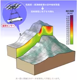
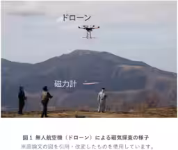
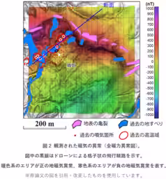
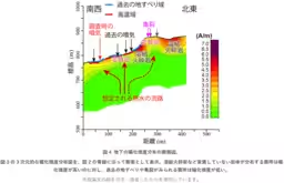
To overcome these challenges, this recent research focused on the western foothills of Aso Volcano in Kumamoto Prefecture, an area with a history of landslides. By deploying drones for low-altitude, high-density magnetic surveys, researchers were able to acquire data with more than four times the spatial resolution compared to previous helicopter surveys. Moreover, by utilizing a proprietary three-dimensional magnetic inversion analysis, they successfully visualized underground structures, revealing detailed distributions of hydrothermal alteration zones.
Findings
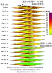
The successful acquisition of high-resolution magnetic anomaly data allowed researchers to infer the distribution of subsurface rock magnetism across various depths. Notably, it was found that regions with significantly low magnetic strength are widespread from surface to depths of several tens of meters, indicating the potential presence of hydrothermally altered zones that could signify geological vulnerabilities. These findings are crucial for understanding how such areas can contribute to slope instability.
An analysis comparing historical landslide occurrences with the identified low magnetic zones revealed that many landslides had taken place near these weak magnetic regions. In particular, the correlation between areas of local magnetic low and sites of seismic-related cracks and collapses suggests that subsurface alteration plays a significant role in the destabilization of slopes.
Implications for Disaster Prevention
Historically, slope disaster risk evaluations have concentrated on visible surface factors, such as slope steepness. However, this research underscores the importance of ‘invisible’ geological elements, such as subsurface structures and the distribution of hydrothermal alteration zones. The combined use of aerial drone magnetic surveys and three-dimensional inversion analysis offers a non-invasive way to identify vulnerabilities in hazardous areas without necessitating physical access.
Going forward, this methodology is expected to be applicable in other volcanic regions and areas with high occurrences of slope disasters. The data collected can serve as foundational information for both national and municipal disaster prevention and mitigation planning.
Future Applications
The strategies developed through this research are not only beneficial for assessing landslide risks but also have the potential to enhance geological surveys in several challenging environments, such as remote mountainous regions where infrastructure development, including bridges, dams, and tunnels, may be planned. In addition, it can aid in the evaluation of mineral resources and the potential of natural hydrogen energy sources.
The detailed results of this groundbreaking research will be published in the journal "Progress in Earth and Planetary Science" on March 4, 2026, further expanding the body of knowledge on utilizing drone technology for geological surveying.
Conclusion
This pioneering approach to utilizing drone technology for magnetic surveying not only opens new frontiers for disaster risk assessment but also emphasizes the importance of advanced methods in understanding and mitigating geological hazards, ultimately contributing to safer environments in vulnerable regions.
Topics Other)


【About Using Articles】
You can freely use the title and article content by linking to the page where the article is posted.
※ Images cannot be used.
【About Links】
Links are free to use.